Newington Cemetery
41-99 Island Road WALLINGTON, GREATER GEELONG CITY
Statement of Significance
The property at 41-99 Island Road, Wallington, is believed to be the site of the Newington Cemetery. No above ground evidence of the private burial site survives. No heritage overlay applies but the site is included on the Victorian Heritage Inventory.
A detailed explanation and history is given in a Memorandum by Council's Heritage Advisor to the Strategic Implementation Unit, 11 December 2015 which includes the following:
Newington Cemetery and the Basis of the former Heritage Overlay.
The Newington Cemetery was identified in the Schedule to the Heritage Overlay in the Greater Geelong Planning Scheme as HO1636. According to the Schedule, the HO applied to all the land within a 20 metre perimeter of the grave plaque at 309 Wallington Road. It would seem that HO1636 was applied to the wrong property (309 Wallington Road) as the location of the Newington Cemetery. It appears that the neighbouring property at 41-99 Island Road may have been the location of the cemetery.
The basis of the heritage overlay was an unpublished research report titled 'Newington Cemetery, Pacey's Hill, beside the Wallington Road, overlooking Barwon Heads', prepared by Susie Zada, Bellarine Historical Society, April 1997. This research report was not an incorporated or reference document in the Greater Geelong Planning Scheme. No statement of significance existed in support of the significance of the Newington Cemetery site articulating its historical and/or social significance, or the criteria and thresholds used to determine such significance. It appears that Ms Zada's research report was prepared to highlight the history of the Newington Cemetery and that it was provided voluntarily to the City of Greater Geelong. It would also appear that Ms Zada was not engaged to prepare a statement of significance.
History of the Newington Cemetery
The research report by Susie Zada was based on meticulous research (numerous documentary sources), oral evidence and field excursions. The location of the cemetery was identified in the death register entry for Joseph Chambers (died 1862) which listed him as being buried at 'Mt. Mitchell Cemetery, Newington, property of Edmond Ferris.'[1] Reference was also made to a typed noted in the Holden Collection at the Geelong Heritage Centre which stated that 'At Ocean Grove . [Grannie Ferris] . was buried in a tiny cemetery with some other early settlers (including some infants) just to the left of the main road where it reaches the top of the cutting, above the great swamp.'[2] Ms Zada gives tables of possible and definite burials at the Newington Cemetery.
In order to determine the veracity of Ms Zada's report, further research was carried out by David Rowe and Pam Jennings. The purpose of this additional research has been to confirm (if possible) the location and extent of Edmond Faress' (Ferris') property, and clarify some of the findings in Ms Zada's report. This research has revealed the following.
On 25 August 1853, John Cumming the younger was the first Crown land purchaser of 284 acres, 1 rood and 8 perches of portion 17, block 4, in the Parish of Bellarine.[3] The southern boundary of the land adjoining the swamp land associated with Lake Connewarre.
In 1854, Cumming subdivided his land (portion 17, block 4) into several allotments.[4] The land was also traversed through its centre by a Government Road. This road forms (in part) the Wallington Road today. Another Government Road was established immediately west of Cummings' original landholding. This forms (in part) Island Road today. Beside the shores of Lake Connewarre was a road called 'Newington Terrace'. It is unclear whether this road was ever created. Other smaller roads were also established.
On 16 November 1854, Cumming sold part of portion 17, block 4, to Edmond Faress (later spelt Ferris), a farmer and fisherman.[5]
Edmond Faress was born in c.1811 at Bridport, Dorsetshire, England, the son of Thomas Faress, a soldier, and Sarah Faress (nee Ford).[6] Following his marriage to Jeanie (or Jennie), they had four children (none having survived by 1863).[7] Jeanie Faress died in 1851.[8] Her death is not recorded on the Victorian Births, Deaths and Marriages Indexes which might suggest that she had passed away prior to Edmund's emigration to Australia. In 1863, he married Susan (Susanna) Chambers, a widow.[9] She was born in c.1818, the daughter of Henry Smith and Priscilla Smith (nee Gillman).[10] From her first marriage to Joseph Chambers (who died in 1862, a friend of Edmond Faress), Susan had 11 children, with five having died by 1863.[11]
In 1863, Faress' occupation was recorded on his marriage certificate as a fisherman of Barwon Heads.[12] It is likely that he was resident at Newington, nearby Barwon Heads as there was a small settlement of fishermen located there at this time. He certainly seems to have combined his occupation as a fisherman with farming as he was listed in the Bellarine Shire Valuation Book for 1863-64 as the owner of 47 acres of grazing land which included a two-roomed house, with a net annual value of £14.[13] In 1865-66, the Valuation Book listed Faress as the owner of block 4, allotment 17, including 1-2 acres for cultivation, 37.2 acres for grazing, a slab hut and post and rail and log fence with a net annual value of £14.[14] In 1866-67, Faress acquired adjoining land comprising allotment 18 of block 4.[15]
Further land was acquired in 1869 when Faress purchased a two acre block from Charles Valentine.[16] This land was situated in the south-western most corner of portion 17, block 4 (corner of Government Road and Newington Terrace).
Between 1869-70 and 1874-75, Faress had acquired further neighbouring land. It comprised a portion of C1 and A1 of allotment 21 of Section 4.[17] No indication is given of any improvements on lots A1 and C1. Some neighbouring allotments had fisherman's huts and gardens noted, suggesting (as previously outlined) that a small settlement had been established on the eastern shores of Lake Connewarre in the 1860s.
In 1873, Faress made application for the parcel of land on the eastern shores of Lake Connewarre, comprising allotment D1 of section 4 (being 48 acres 1 rood and 33 perches).[18] There, he built a two-roomed dwelling constructed partly of stone and partly of lath and plaster.[19] He grew oats and potatoes on this land, which, according to early maps, indicated that it 'occasionally flooded.'[20] In 1875, Faress sold a small portion of his original landholdings (north-east corner) to Angus Mackay, Minister for Public Instruction,[21] presuming for a new State School, but the new school was apparently located 20 chains east of the Wesleyan chapel located 376 Wallington Road (north of Faress' property at the south-east corner of Wallington and Hardings Roads).[22]
Although Faress had acquired several landholdings in the Newington area from the 1850s, his permanent family residence was located on the original landholdings comprising part of portion 17, block 4. In 1876, he described the improvements on this property as including a 'newly built' dwelling where his family resided.[23] It was situated one quarter of a mile from his low-lying licensed land on the shores of Lake Connewarre.[24] It was also in 1876 when Faress was successful in obtaining freehold of this land.[25] Faress' final land acquisition was 7 acres of land located between his original landholdings purchased in 1854 and his land acquired from Charles Valentine in 1869. It was sold to him by Ann Pike in 1886.[26]
Edmond Faress died on 3 March 1887. It was reported in the Geelong Advertiser as follows:
At noon yesterday the deputy- coroner Mr N J Maude, conducted an enquiry at the hospital upon the remains of the late Edmund Ferris, farmer, of Newington, who met his death accidentally at the Market Square of Thursday morning.
The deceased was 78 years of age. Mrs Ferris stated that she had last seen her husband alive when he left for Geelong on Thursday morning, in a spring cart, loaded with fruit. She had been married to him for 25 years, and he always enjoyed good health.
Mr James Sinclair, a farmer, residing at East Geelong, stated that whilst the deceased was taking a case of apples from his cart in Mr H F Richardson's sale yards at half-past nine o'clock on the previous morning he fell backwards into a channel, his head striking the inner stone next to the kerbstone of the channel. Witness lifted up deceased who was conveyed to a vehicle outside the yard, and subsequently removed to the hospital. Mr Ferris appeared to be quite dead when witness lifted him from the ground.
Joseph Lang, a van driver, residing in Mary Street, Newtown, deposed that whilst upon the van stand in Lt Malop St. He was requested to convey the deceased to the hospital. Upon arriving at the institution the body was placed in the morgue. Dr Newman, resident surgeon at the hospital deposed that when the deceased was brought to the hospital at 10am on Thursday, life had been extinct for only a few minutes. There was a quantity of clotted blood filling the left ear, and a large bruise over the left side of the scalp, behind the ear. Witness had made a post mortem examination of the body, which was that of a well-nourished man. There was considerable bruising of the integuments of the left side of the head and neck. The left side of the skull was fractured extensively from the back of the ears to the occiput. The substance of the brain below the seat of fracture was also considerably bruised. The heart was greatly hypertrophied, and its valves very much diseased, the aortic valves being especially affected. The kidneys were somewhat contracted. The immediate cause of death was fracture of the skull, the result of the fall, which was probably due to syncope from heart disease.
The deputy coroner gave a decision in accordance with the medical testimony.[27]
Faress' real and personal estate, valued at £440/14/4, was outlined in the Statement of Assets and Liabilities as part of the Probate of his Estate as follows:
162 acres and 1 perch of freehold land in the Parish of Bellarine at Neweington County of Grant being portion C1 and A1 Allotment 21 Section 4 Allotment D1 of Section 4 and parts of Portions 17 and 18 of Block 4 upon which is erected a 4 roomed Farm house (front of weatherboard and sides and back of wattle and daub) roof of iron is fenced partly with posts and railws and partly with posta nd 2 wires was in occupation of deceased at date of decease and now in occupation of widow of deceased would let at £100 per annum .[28]
Although a burial ground was not recorded as part of Faress' assets, this was not uncommon. Other private 19th century burial grounds have not appeared in official records and particularly the assets listed in the Probates of other deceased early owners, such as the Gange family burial ground that once formed part of the 'Garrangill' property, Mt Mitchell, Drysdale, and the Russell family cemetery at Wurrook homestead, near Rokewood.[29]
Likely Location of the Newington Cemetery
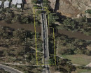
The basis to the existing heritage overlay is an "X" marked on a map in the City's property file for the Newington Cemetery.
A cross reference of the photographs taken at the re-unveiling of commemorative plaque in 1997 (that had been first lad by descendants in 1989 and rediscovered by Jim Barry)[30] with aerial imagery (which includes the pipe that until recently projected above the plaque), suggests that the cemetery is located at 41-99 Island Road, Wallington. It is recognised that the marking up of the site on a map in 1997 occurred long before aerial and other digital imagery was available to accurate determine the location. No on-site investigations have been carried out as part of this assessment to confirm the location of the plaque.
It is noted that there has been some conjecture about the existence of the cemetery at 41-99 Island Road. However, the historical evidence suggests that the cemetery is highly likely to be situated on this land. The eastern portion of this property generally equates to the original landholdings acquired by Edmond Faress in 1854.
Some recorded deaths give a compelling case for the subject site at 41-99 Island Road as the location of the cemetery. For example, the death certificate of Joseph Chambers (who died in 1862) states that the location of his burial was 'In the ground of Edmund Farris, Newington.'[31] The only land known to have been owned by Faress at this time was the eastern portion of the land now comprising 41-99 Island Road.
Another burial confirmed at Newington was that of the infant, Priscilla Luckow, in 1885. Her death certificate did not give the specific location other than Newington but one of the names listed as a witness of the burial was 'E. Faress.'[32]
Not all the burials outlined in Ms Zada's report appear to be located at 41-99 Island Road. The burial of Edmond Faress' first wife in 1851, for example, is unlikely to have been made at Newington as Faress was not owner of the land at this time. There has also been some confusion about the Gange family burial ground at the former family property 'Garrangill', Mt Mitchell, Drysdale, and the recording of burials related to the Newington ground. The Shire of Bellarine Valuation records for 1888-89 referred to in Ms Zada's research report listed two 28 acre properties out of sequence. They comprised land as part of the Gharinghill estate at Ebden, not Newington.[33] Ebden was apparently named after C.H. Ebden, the 'original purchaser of the land north of Drysdale on Beacon Point Road.'[34] There is no historical or physical association between the Newington or Mt Michell (Gange family) cemeteries.
Further documentary evidence of the location of the cemetery might be confirmed through historic aerial photographs available at Aerial Photography Library, 57 Cherry Lane, Laverton. Any available early 20th century photograph could possibly show the early fencing that apparently existed around the cemetery.
Physical confirmation of the burials at 41-99 Island Road may be possible through geotechnical and archaeological investigations by suitably qualified archaeologists. Recent conjecture surrounding the Gange family burial site at Drysdale has resulted in geotechnical investigations that appear to have confirmed burials on the site. Further archaeological investigations are continuing. [1] S. Zada, 'Newington Cemetery: Pacey's Hill, beside the Wallington Road, overlooking Barwon Heads', unpublished manuscript, Bellarine Historical Society, p.research result 1.
[2] Ibid., p. research procedures 1.
[3] Land Application No. 69756C, General Law Library, Land Information Centre, Laverton.
[4] Ibid.
[5] Ibid.
[6] Faress E. & Chambers, S., Marriage Certificate, 463, 24 February 1863, Registry of Victorian Births, Deaths & Marriages, Department of Justice.
[7] Ibid. The name of Faress' first wife is taken from Zades, op.cit.
[8] Ibid.
[9] Ibid.
[10] Ibid.
[11] Ibid.
[12] Ibid.
[13] Shire of Bellarine Valuation Book, 1863-64, Geelong Library & Heritage Centre.
[14] Ibid., 1865-66.
[15] Ibid., 1866-67. See also E. Faress, Probate Administration files, 1887, VPRS 28/P2 Unit 219 Public Record Office Victoria (PROV).
[16] Land Application No. 69756C, op.cit.
[17] Shire of Bellarine Valuation Books, 1869-1875, op.cit. & Faress, op.cit.
[18] E. Faress, Application for Crown Grant by Licensee, 11 April 1876, VPRS 625/P0 Unit 355 PROV.
[19] Ibid.
[20] J.L. Shaw, 'Country Lots, Portion of Allotment 21 Section 4', Parish of Bellarine plan, 31 March 1869, B/80E put-away plan, Landata at https://www.landata.vic.gov.au/
[21] Land Application No. 69756C, op.cit.
[22] L.J. Blake (ed.), Vision and Realisation: a centenary history of state education in Victoria, Education Department of Victoria, Melbourne, p.1030.
[23] Faress, Application for Crown Grant by Licensee, op.cit.
[24] Ibid.
[25] Ibid.
[26] Land Application No. 69756C, op.cit.
[27] Geelong Advertiser, 5 March 1887, p.3.
[28] Faress, Probate Administration files, op.cit.
[29] See for example, M. Gange, Probate Administration files, 1882, VPRS 28/P2 Unit 143 PROV & T. Russell, Probate Administration files, 1920, VPRS 28/P3 Unit 1105 PROV.
[30] Zada, op.cit. Jim Barry also supplied Susie Zada with a map marking the location of the plaque.
[31] J. Chambers, death certificate, entry 47, 24 August 1862, Registry of Births, Deaths & Marriages, Department of Justice, Melbourne.
[32] P. Luckow, entry 418, 11 March 1885, Registry of Births, Deaths & Marriages, Department of Justice, Melbourne.
[33] Shire of Bellarine Valuation Book, 1888-89, op.cit.
[34] I. Wynd, Balla-wein, A history of the Shire of Bellarine to 1993, 2nd edn., Bellarine On-Line for Bellarine Historical Society, Inc., Drysdale, 2005, p.199.
-
-
-
NEWINGTON CEMETERY
 Victorian Heritage Inventory
 -
"Fox Hut"
 Greater Geelong City
 -
Uniting Church
Greater Geelong City
-
-