Back to search results
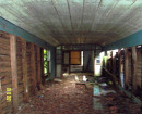
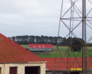
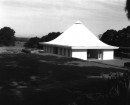
GROVILLE FOREST, KALKALLO - FARM COMPLEX SITE 1
200 DONNYBROOK ROAD MICKLEHAM, HUME CITY
GROVILLE FOREST, KALKALLO - FARM COMPLEX SITE 1
200 DONNYBROOK ROAD MICKLEHAM, HUME CITY
All information on this page is maintained by Heritage Victoria.
Click below for their website and contact details.
Victorian Heritage Inventory
On this page:
Statement of Significance
Data has been updated as a result of the Outer Western Metro Project, Context, March 2010. Site originally recorded as Groville Forest Rural Landscapein 2007 by Andrew Long and Associates as part of the Kalkallo Park, Mickleham: Aboriginal and Historical Cultural Heritage Study.
Show more
Show less
-
-
-
-
GROVILLE FOREST, KALKALLO - FARM COMPLEX SITE 1
 Victorian Heritage Inventory
-
-