Back to search results
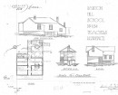
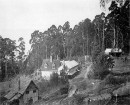
SHEPHERDS HUT 1
GERRINGERRUP-MINHAMITE ROAD GERRIGERRUP, MOYNE SHIRE
SHEPHERDS HUT 1
GERRINGERRUP-MINHAMITE ROAD GERRIGERRUP, MOYNE SHIRE
All information on this page is maintained by Heritage Victoria.
Click below for their website and contact details.
Victorian Heritage Inventory
On this page:
Statement of Significance
The hut is of local cultural significance and moderate scientific significance. The hut is an example of property management on large stations in the region.
Show more
Show less
-
-
-
-
SHEPHERDS HUT 1
 Victorian Heritage Inventory
-
-