Back to search results
BRISTOL HILL HISTORICAL LANDSCAPE
GLADSTONE STREET (PYRENEES HIGHWAY) MARYBOROUGH, CENTRAL GOLDFIELDS SHIRE
BRISTOL HILL HISTORICAL LANDSCAPE
GLADSTONE STREET (PYRENEES HIGHWAY) MARYBOROUGH, CENTRAL GOLDFIELDS SHIRE
All information on this page is maintained by Heritage Victoria.
Click below for their website and contact details.
Victorian Heritage Inventory
On this page:
Statement of Significance
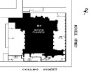
Site has limited ability to provide information about gold mining era. It is of local cultural heritage significance.
Show more
Show less
-
-
-
-
FORMER MARYBOROUGH HIGH SCHOOL
 Victorian Heritage Register H2143
 -
CONWAY'S WORKINGS AND DAM
 Victorian Heritage Inventory
 -
BRISTOL HILL EASTERN REEF OPEN CUT
Victorian Heritage Inventory
-
-