Back to search results
ARMISTEAD’S SAWMILL
KENNETT RIVER ROAD, KENNETT RIVER VIC 3234
ARMISTEAD’S SAWMILL
KENNETT RIVER ROAD, KENNETT RIVER VIC 3234
All information on this page is maintained by Heritage Victoria.
Click below for their website and contact details.
Victorian Heritage Inventory
On this page:
Statement of Significance
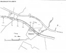
Armistead’s Sawmill was set up by Syd Armistead between Kennett River and Hitchcock Gully in 1941. The settlement originally included a sawmill and eight houses for mill workers but grew in size to be one of the largest processors of timber in the region by 1950 (Sheehan 2003). The sawmill site was built between Cassidy Drive and Kennett Road, to the west of the Great Ocean Road and initial used equipment sourced from the 1930’s ACA sawmill in Lorne (Houghton 2001). Timber was initially logged from along Hitchcock Gully and winched up to the mill site using an 700m horse drawn narrow gauge tramway on the south western side of Hitchcock Gully until 1945. Gravel logging roads were constructed further north in Hitchcock Gully and along Grey River Road, and trucks were used to transport logs to the mill from 1945 onwards.
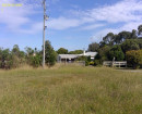
The Armistead’s Sawmill site contains no extant standing structures, however it is considered that the place has ‘moderate potential’ to contain archaeological remains that are, or are likely to be, in a condition that will allow information to be obtained that will contribute to the understanding of the site. Any potential structural elements and landform modification at Armistead’s Sawmill would likely date from the establishment of the sawmill in 1941, which utilised earlier 1930s technology transported from other timber processing sites in the Otways. Aerial imagery from 1952 onwards indicate that the site extent has not been developed since the sawmill ceased operation in the 1950s.
The place has historical significance at a local level, as it is associated with development of the Kennett River township after the Great Ocean Road was opened and provided access to previously inaccessible parts of the Otway Coast. It is historically associated with the timber industry of the Otways, which was one of the major industries in the region during the 19th and early-20th centuries. The sawmill site and tramway at Armistead’s Sawmill have scientific significance as representative example of the late stage timber industry in the Otway region.
Show more
Show less
-
-
-
-
NORTH MELBOURNE POTTERY
 Victorian Heritage Inventory
 -
STONY CREEK SLIPWAY
Victorian Heritage Inventory
-
SEASONING WORKS SITE AND TERRACOTTA LUMBERWALL
Victorian Heritage Inventory
-
-