Back to search results
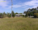
FORBES ROAD HUT RUIN
FORBES ROAD, TERRICK TERRICK EAST VIC 3573
FORBES ROAD HUT RUIN
FORBES ROAD, TERRICK TERRICK EAST VIC 3573
All information on this page is maintained by Heritage Victoria.
Click below for their website and contact details.
Victorian Heritage Inventory
On this page:
Statement of Significance
The Forbes Road Hut Ruin or “Dustans Place” is assessed as having archaeological value in a local context under the Peopling Victoria’s places and landscapes Framework (2.1, Living as Victoria’s original inhabitants); and Transforming and managing land and natural resources Frameworks (4.1 Living off the land, 4.3 Grazing and raising livestock, 4.4 Farming).
Show more
Show less
-
-
-
-
NORTH MELBOURNE POTTERY
 Victorian Heritage Inventory
 -
STONY CREEK SLIPWAY
Victorian Heritage Inventory
-
SEASONING WORKS SITE AND TERRACOTTA LUMBERWALL
Victorian Heritage Inventory
-
-