NAR NAR GOON STATION PRECINCT
CARNEY STREET NAR NAR GOON, CARDINIA SHIRE
-
Add to tour
You must log in to do that.
-
Share
-
Shortlist place
You must log in to do that.
- Download report
Statement of Significance
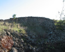
-
-
NAR NAR GOON STATION PRECINCT - History
Stationmaster's house -
The Cardinia Shire area originally formed part of the territory of the Bunurong tribe. From the 1840s, the area attracted a large number of pastoralists, due to its quality agricultural land and plentiful water supplies. A number of homesteads and large pastoral estates were established throughout the mid-19th century, with the proposed site comprising a portion of a 16,000 acre pastoral run named Mt. Ararat 2, from as early as 1844 (Graeme Butler & Associates 1996). Agricultural land use within the area involved the modification and digging of multiple drainage lines to expand upon and improve access to water within Cardinia Shire. The most notable drainage project to benefit Cardinia Shire was the draining of Koo-wee-rup Swamp, which provided an abundance of fertile farmland for the area (RBA 2020:14).
The isolated nature of the pastoral runs established within Cardinia Shire began to change with developments in transport infrastructure in the 1870s. The section of the Eastern Railway Line (now the Gippsland rail line) that connected Melbourne to Pakenham / Nar Nar Goon and towards Gippsland began construction in the 1870s,
with the first section of this line between Melbourne and Pakenham opened in 1877. The construction of Nar Nar Goon station followed shortly thereafter, opening in 1881 (GJM Heritage 2021). An east-west route along Gippsland Road (now the Princes Highway) was also completed in the 1870s, providing both road and rail links
between Melbourne and Cardinia Shire. The construction of the railway line encouraged further development within the area, and by the early 20th century, both Pakenham and Nar Nar Goon had established themselves as key population centres within the Cardinia Shire Local Government Area (LGA). These townships saw additional expansion after World War 2, as a second wave of settlement encouraged by soldiers returning from war occurred (Victorian Places 2021).
No plans or historical images of the residence were identified.
The construction of the building is estimated to have occurred in the late 1800’s- early 1900’s. Historic research could not confirm absolutely that the building in question is the station masters residence, however a number of factors indicate its function in association with
railway operation:
• The form of the residence, which appears as cruciform in plan, and the layout of the yard and ancillary structures, is comparable to other stationmasters residence’s listed on the VHI, such as the Moreland Station Masters Residence included in H7822-2386, and the Beaconsfield Station Masters residence listed on the local Heritage Overlay, Cardinia Shire (HO17).
• The location of the residence alongside the rail corridor. While other buildings are in similar proximity in the 1940’s (Figure 2), the only remaining residence in this area in 1979 is the residence in question (Figure 3). The length of time this structure existed within the Gippsland rail corridor (into the late 1970s and
early 1980s), indicates an ongoing role in the operation of the rail.
Station and platform -
The section of the Eastern Railway Line (now the Gippsland rail line) that connected Melbourne to Pakenham / Nar Nar Goon and towards Gippsland began construction in the 1870s, with the first section of this line between Melbourne and Pakenham opened in 1877. The construction of Nar Nar Goon station followed shortly thereafter, opening in 1881 (GJM Heritage 2021). An east-west route along Gippsland Road (now the Princes Highway) was also completed in the 1870s, providing both road and rail links between Melbourne and Cardinia Shire. The construction of the railway line encouraged further development within the area, and by the early 20th century, both Pakenham and Nar Nar Goon had established themselves as key population centres within the Cardinia Shire Local Government Area (LGA). These townships saw additional expansion after World War 2, as a second wave of settlement encouraged by soldiers returning from war occurred (Victorian Places 2021). The former station can be seen in historical aerial imagery of the station from 1947 (Figure 2). The image shows the station building and adjoining platform on the northern side of the rail corridor. A photo dated to 1987 shows the original station building, a wooden framed weatherboard structure (Figure 3). The station was subsequently upgraded with a new rail alignment along the northern side of the station building, converting the station and platform into an island platform layout in 1996 (see Figure 4 and Figure 5). At this time, the original station building was demolished, and the current layout established (Figure 1).
Workers Camp -
The construction of Nar Nar Goon station was completed in 1881 (GJM Heritage 2021). An east-west route along Gippsland Road (now the Princes Highway) was also completed in the 1870s, providing both road and rail links between Melbourne and Cardinia Shire. The construction of the railway line encouraged further development within the area, and by the early 20th century, both Pakenham and Nar Nar Goon had established themselves as key population centres within the Cardinia Shire Local Government Area (LGA). These townships saw additional expansion after World War 2, as a second wave of settlement encouraged by soldiers returning from war occurred (Victorian Places 2021). The construction of the goods shed on a raised platform and ancillary structures is attributed to the period of early rail operation. An aerial photograph dated 1947 shows the structures to the south of the main rail alignment. A former siding alignment is also indicated extending to the south of the goods shed, although removed by the time of the 1947 image (Figure 2). Historical aerial imagery of the associated yard surfaces dated to 1979 shows a notable changes in this area, with trucks, spoil piles and other features present that suggest the development of this location into the current carpark. The goods shed and structures are still present at this time. Photographs of the shed and associated buildings were taken in the 1980s, presumably prior to the development of the station complex and their demolition (Figure 4, Figure 5). These images establish that the shed and associated buildings were wooden-framed structures with corrugated iron exteriors, positioned on raised platforms. The platforms were timber with metal support pylons. Track realignment plan drawings associated with station redesign show the position of the goods shed to the south of rail sidings as of 1996 (Figure 6). The later construction of a cement goods platform was to the east of the former goods shed is evident in (Figure 1, Figure 7) and remains intact today. The absence of this feature in 1947 aerial imagery suggests its construction in the late 20th century. This platform has not been included in the proposed VHI extent based on its recent age. The early goods shed and associated wooden platform were subsequently demolished along with the associated
smaller built structures and their platforms. The broader goods yard/ workers camp area was developed from the 1970’s (Figure 3). Evidence of preserved footings associated with the former goods shed platform are referenced as being present at the location in a historical heritage assessment report currently under preparation by GJM Heritage (GJM Heritage 2021). These platform footings are most likely the remnants of the steel support pylons shown in Figure 4. Figure 5. While the work camp area may not contain any built archaeological features, it would have played an important in supporting the operation of Nar Nar Goon Station and in particular the movement and processing of goods. The area is therefore associated with the adjacent former buildings and may retain archaeological materials of heritage significance. For this reason it has site card be lodged for its registration on the VHI.
NAR NAR GOON STATION PRECINCT - Interpretation of Site
Stationmaster's house - No surface archaeological features are evident at the location however subsurface components of the residential structure and associated outbuildings may be preserved at the location. Due to its age and the functional contribution the station manager’s residence would have played in ensuring the operation of Nar Nar Goon Station, it may be classified as an area of archaeological potential under the Heritage Act 2017 (Vic), and therefore protected from harm. Station and platform - Based on the site history and imagery, it is likely that the original station structure was built in the early 20th century and demolished, between 1987 and 1996. No surface archaeological features are evident at the location however subsurface components of the residential structure and associated outbuildings may be preserved at the location. Areas where archaeological features associated with the former station and platform may have been retained have been mapped atop recent aerial imagery of Nar Nar Goon station. Due to the suspected age and original purpose of these platform structures, they may be classified as areas of archaeological potential under the Heritage Act 2017 (Vic), and therefore protected from harm. Workers Camp - The location of the former work camp and goods sheds, where archaeological features may have been retained, have been mapped atop recent aerial imagery of Nar Nar Goon station. Due to the functional contribution the work camp area and goods shed have had towards the operation of Nar Nar Goon Station, it may be classified as an area of archaeological potential under the Heritage Act 2017 (Vic), and therefore protected from harm.
Heritage Inventory Description
NAR NAR GOON STATION PRECINCT - Heritage Inventory Description
The proposed site comprises a section of the Gippsland rail corridor that contained the former station manager’s residence, former station building, platform and workers camp/good shed area for Nar Nar Goon Station. The archaeological potential of this section of the Gippsland rail corridor was first identified in a historical heritage report prepared by GJM Heritage of the Nar Nar Goon area (GJM Heritage 2021) and expanded upon in another historical heritage assessment prepared by Eco Logical Australia (ELA 2021) for the proposed Pakenham Level Crossing Removal Project (LXRP).
-
-
-
-
-
NORTH MELBOURNE POTTERYVictorian Heritage Inventory
-
STONY CREEK SLIPWAYVictorian Heritage Inventory
-
SEASONING WORKS SITE AND TERRACOTTA LUMBERWALLVictorian Heritage Inventory
-
-