Back to search results
COLAC POLICE RESERVE
40-46 QUEEN STREET COLAC, COLAC OTWAY SHIRE
COLAC POLICE RESERVE
40-46 QUEEN STREET COLAC, COLAC OTWAY SHIRE
All information on this page is maintained by Heritage Victoria.
Click below for their website and contact details.
Victorian Heritage Inventory
On this page:
Statement of Significance
What is significant?
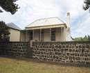
A Government Gazette from 1861 shows £450 was granted to build the bluestone police lock-up and other associated structures. These were likely to be a residence and station with associated outbuildings. In 1869 the buildings are described as being in a “delipidate state” due to flooding, repairs were undertaken in the 1870s with more development occurring on the site. Several additions, alterations and repairs are listed as public works throughout the nineteenth century. From these tenders, several buildings are listed on the site. These include:
- 1861 Police lock-up
- 1860s-1870 Police residence
- 1870s-1880 Police Station
- 1880 Police Stables
- 1880-1890 Police Court House
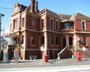
A photograph from the c.1890s shows three prominent buildings fronting Queen Street. Additional substantial buildings can be seen to the rear of the police lock-up and courthouse. A c.1905 photograph shows the police court from the rear while the Barongarook Creek water level was high. The slope from the rear fence is depicted as steep moving down towards the creek.
The 1927 aerial photograph shows a developed block with a number of buildings to the rear of the courthouse and a c.1950 aerial photograph shows outbuildings to the rear of the police lock-up and courthouse. A Scout Hall was constructed in the 1940s on the public reserve by the Barongarook Creek. The 1889 Courthouse was demolished in the 1970s to make way for modern facilities. The only nineteenth century building remaining on site is the bluestone police lock-up in the centre of the site. Photographs showing the construction of the c.1920 police station on the corner of Queen and Dennis Street display an amount of fill underlying the newly constructed building.
The site currently comprises a modern police station fronting Queen Street, Colac. Over half the site comprises buildings constructed within the last 10 years. The c.1861 bluestone police lock-up is located to the rear of these buildings with a concrete carpark to the east. To the rear of the police station is an undeveloped grass area. The 1940s scout reserve is between the creek and the open grassed area. Therefore, the site has moderate potential to contain significant archaeological deposits, features and/ artefacts associated with the nineteenth century occupation of the site.
The Colac Police Reserve is of local historical significance as it displays the development of the township and may provide archaeological evidence on regional police reserves, which is currently underrepresented in the Heritage Inventory.
Updated 27 May 2022
How is it significant?
Why is it significant?
Show more
Show less
-
-
-
-
NORTH MELBOURNE POTTERY
 Victorian Heritage Inventory
 -
STONY CREEK SLIPWAY
Victorian Heritage Inventory
-
SEASONING WORKS SITE AND TERRACOTTA LUMBERWALL
Victorian Heritage Inventory
-
-