Back to search results
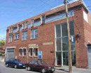
PARKERS ROAD GATEHOUSE
RAIL CORRIDOR, DOWNSIDE: CORNER OF PARKERS ROAD AND FRANKSTON RAIL LINE. 92 PARKERS ROAD, PARKDALE, VIC, 3195
PARKERS ROAD GATEHOUSE
RAIL CORRIDOR, DOWNSIDE: CORNER OF PARKERS ROAD AND FRANKSTON RAIL LINE. 92 PARKERS ROAD, PARKDALE, VIC, 3195
All information on this page is maintained by Heritage Victoria.
Click below for their website and contact details.
Victorian Heritage Inventory
On this page:
Statement of Significance
What is significant?
The Parkers Road Gatehouse was an important element of the Frankston Railway Line during the growth of early suburban railways, as manual operation of the level crossing gates was required. Due to this, accommodation was necessary for the employees staffing the level crossings. The Gatekeeper was therefore integral for the operation of trains running to schedule and ensuring the public’s safety. The Parkers Road Gatehouse, inclusive of the primary residence, shed, and any associated archaeological deposits, thus have the potential to provide detail regarding the early operation of suburban railways and daily life during the early 20th century in greater Melbourne.
How is it significant?
The Parkers Road Gatehouse was an important element of the Frankston Railway Line during the growth of early suburban railways, as manual operation of the level crossing gates was required. Due to this, accommodation was necessary for the employees staffing the level crossings. The Gatekeeper was therefore integral for the operation of trains running to schedule and ensuring the public’s safety. The Parkers Road Gatehouse, inclusive of the primary residence, shed, and any associated archaeological deposits, thus have the potential to provide detail regarding the early operation of suburban railways and daily life during the early 20th century in greater Melbourne.
Why is it significant?
The Parkers Road Gatehouse was an important element of the Frankston Railway Line during the growth of early suburban railways, as manual operation of the level crossing gates was required. Due to this, accommodation was necessary for the employees staffing the level crossings. The Gatekeeper was therefore integral for the operation of trains running to schedule and ensuring the public’s safety. The Parkers Road Gatehouse, inclusive of the primary residence, shed, and any associated archaeological deposits, thus have the potential to provide detail regarding the early operation of suburban railways and daily life during the early 20th century in greater Melbourne.
Show more
Show less
-
-
-
-
NORTH MELBOURNE POTTERY
 Victorian Heritage Inventory
 -
STONY CREEK SLIPWAY
Victorian Heritage Inventory
-
SEASONING WORKS SITE AND TERRACOTTA LUMBERWALL
Victorian Heritage Inventory
-
-