City Fringe Heritage Area
-
Add to tour
You must log in to do that.
-
Share
-
Shortlist place
You must log in to do that.
- Download report
Statement of Significance
What is Significant?
The City East Heritage Area including residential buildings and a fewpublic and commercial properties dating from the Victorian, Federationand Interwar periods as well as mature street plantings and early streetinfrastructure including basalt kerbing and channelling. High qualityresidences constructed in the 1950s and circa1960s to Eastern Beach Road(or adjacent) are also significant.How is it Significant?
The City East Heritage Area is of local historic and aesthetic significance to the City of Greater Geelong.
Why is it Significant?
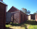
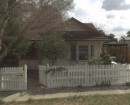
Historically, the City East Heritage Area is significant as a mostly residential area that was largely developed during the Victorian, Federation and Interwar periods when many buildings were erected on the fringe of the commercial centre of Geelong. It is significant for the large percentage of high quality housing which reflects its premier location on the hill overlooking both Corio Bay and the Botanic Gardens and in close proximity to the commercial centre. Most of the precinct is located in the Eastern Extension of the town which was surveyed in 1854, five years after the first land sales in Geelong. Substantial houses from this period, including Corio Villa and Merchiston Hall, are indicative of the wealth in the Geelong area at this time. Remaining early cottages from this period are also significant though most of these have been lost (several remain in the nearby Austin Park and Environs Heritage Precinct).
Following a period of slow development during the 1860-70s, many houses were erected in the Late Victorian, Federation and Interwar periods, reflecting the growth in Geelong during this time. Development from each of these periods included substantial houses built in premier locations such as Eastern Beach Road, Garden Street, Ryrie Street and Pevensey Crescent. By the mid-1920s much of the precinct had been developed, though large holdings including substantial gardens remained to the north overlooking Corio Bay. As these larger allotments were subdivided, other high quality housing was erected on Eastern Beach Road, with some land not developed until the mid-20th century.
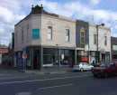
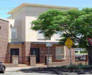
The City East Heritage Area also includes two church complexes which have buildings surviving from the key periods of development. The Shenton Methodist Church complex includes an early Victorian period hall, a Federation period house and an Interwar period church whilst the St Andrew's Uniting Church is a Federation period building with later limestone cladding. Also located in the precinct are two Victorian era commercial premises (shop and former hotel) that bookend Malop Street, a key thoroughfare in the area. The former hotel on the corner of Swanston Street was established in the first phase of development that occurred in the precinct during the 1850s and the late Victorian shop on the corner of Garden Street was constructed when the population of the City East Heritage Area quickly increased. (Criterion A)
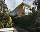
The City East Heritage Area is of aesthetic significance for the largely intact residences constructed from the 1850s to the 1940s within streetscapes unified by grassed verges, groups of mature trees and early infrastructure including sections of basalt kerbing and channelling. The precinct has a distinctive mid-19th century street layout which includes the curved street Pevensey Crescent and the St Andrew's Cross formed by Sydney Avenue and Sydney Parade.
There are fine residences from the Victorian, Federation and Interwar periods with some good examples from the mid-20th century to Eastern Beach Road. Houses in the precinct range from small timber cottages to substantial two and three storey masonry residences. As a whole, the precinct includes a large percentage of commodious residences when compared to other nearby residential precincts and includes many architect designed homes. Some houses, particularly those dating from the Interwar period, retain original fences to the street boundary.
The two church complexes within the City East Heritage Area are of note and are located at key corner sites. Both churches were designed by noted architects of the period - St Andrew's by Laird and Buchan Architects and the former Shenton Methodist Church by Frederick Purnell. (Criterion E)
-
-
City Fringe Heritage Area - Physical Description 1
The City East Heritage Area is a large residential precinct located to the east of the Geelong Central Business District and has two defined boundaries - Corio Bay/Eastern Beach Road to the north and the Botanic Gardens/Garden Street to the east. The Geelong commercial centre forms an effective boundary to the west in the vicinity of Swanston and England streets. The precinct slopes up towards the Botanic Gardens to the east and Sydney Parade/Sydney Avenue located close to the southern boundary. Most of the buildings are residential though there are a two churches in the southern part and a shop and former hotel to Malop Street.
Within the precinct, there are areas which consist of a high percentage of graded building stock, including Ryrie Street, the south side of Park Street and the west side of the southern end of Swanston Street. The significant and contributory buildings date from the mid-19th century though to the mid-20th century, with a fairly consistent representation from the principal periods - the Victorian, Federation and Interwar. The majority of houses in the precinct are detached, though there are several examples of attached pairs, most of which were constructed during the Victorian period. Most of the original allotments shown on the Parish Plan have been subdivided into smaller lots, though a few of the mid-19th century holdings remain on Pevensey Crescent.
The houses range in scale from small single storey timber cottages to substantial two/three storey residences which were erected in premier locations close to the waterfront or on the higher land fronting Garden Street and overlooking the Botanic Gardens. The precinct is distinguished by the higher percentage of substantial houses, many of which are located on premier sites. On Eastern Beach Road there are substantial houses from each period including the 1850s Corio Villa at no. 56-58, the attached Victorian pair Arlston & Jesmond House at nos 32 and 34, a substantial Federation period residence at no.46 and the Interwar bungalow Rosehaug at no. 48. In addition, there are also a few good examples from the mid-20th century. Both the substantial 1856 Merchiston Hall at 2a Garden Street and the Victorian period Longville House at 2 Fitzroy Street also originally overlooked the Bay as they were initially located on large allotments which extended to Eastern Beach Road. These holdings have subsequently been subdivided and later residences constructed between the earlier houses and the waterfront.
Other substantial houses in the precinct are located on the main thoroughfare of Ryrie Street which is situated close to the ridge, and opposite the park on Pevensey Crescent. One of the most substantial houses to Ryrie Street is the two storey Belleville at 350 Ryrie Street which retains early outbuildings. Notable residences to Pevensey Crescent include the two storey Bells Terrace (nos 9, 11, 13 and 15) and Tooronga (no. 17). Some large houses are also located on Malop Street which is another main thoroughfare in the precinct. Many of those at the west end of Malop Street, in closer proximity to Geelong's commercial centre, have been adapted for use as professional suites or medical practices.
One of the earliest houses in the precinct, Woodlands, is located at 345 Ryrie Street, though its large holdings have progressively been subdivided. Another of the earliest houses in the precinct is the two storey 1854 residence at 8 Swanston Street which is constructed of Singapore Cedar and is possibly prefabricated.20 A couple of early single storey cottages also remain in Wheeler Place.
The palate of materials in the precinct varies depending on the scale of the residence and the period of construction. Most houses are constructed of timber, though more substantial examples are often masonry (face brick and/or render).The roofs of more modest houses are mostly clad in corrugated metal sheeting, whilst more substantial Victorian period houses often have a slate roof. Houses from the Interwar period regularly have terracotta clad roofs and clinker brick walls. Original windows and doors from each period are timber-framed though in some instances they have been replaced with modern alternatives.
The Victorian period houses tend to be symmetrical (though there are asymmetrical examples) with hipped roofs, a central doorway and a double-hung sash window to each side. Typically they have a verandah that extends the width of the facade and for some of the larger houses the verandah returns to one or both sides. Original verandahs have a timber or tiled deck and often have columns with capitals supporting a cast iron frieze. Places from the Victorian period tend to have timber brackets and panels to the eaves and many retain original chimneys that are either face brick or rendered. Fine, intact weatherboard houses include those at 6 and 8 Garden Street and 64 Sydney Parade as well as the unusual mirrored pair at 36 and 38 Alexandra Avenue. Intact masonry examples include residences at 347-349 & 371 Ryrie Street.
The Federation period houses often display Arts and Crafts influences in their asymmetrical format, frequently incorporating varied roof forms and timber details. Houses from this period often have an asymmetrical projecting bay and an offset or side verandah. The prominent roofs tend to be steeply pitched and include a gable end with timber battens, roughcast sheeting or timber shingles. The chimneys are tall, red brick and often have a band of rough cast render. The intact verandahs commonly have turned timber posts and possibly an ornate cast iron or geometric timber frieze. Several examples have complex roof forms which incorporate a projecting tower. This includes 244 and 248 Malop Street. Noteworthy Federation period examples include St Andrew's Presbyterian Manse at 343 Ryrie Street, the residence at 8 Sydney Avenue and the largely intact group of four timber houses at 44, 46, 48 & 50 Swanston Street with distinctive timber decoration. Also of note are the Alexander Miller Memorial Homes at 324-332 Ryrie Street designed by Laird and Buchan.
Houses from the Interwar period mostly date from the early 1920s and are usually bungalows with low pitch gable roofs often clad in terracotta tiles with exposed rafter ends. Houses from this period typically have grouped timber sash windows, many having leadlight. Gable ends often incorporate battened sheeting, timber shingles and/or timber vents. The bungalows usually have an offset porch with a combination of rendered piers and/or timber posts. Good examples of this type include the brick bungalow at 36 Eastern Beach Road and the timber bungalow at 69 Sydney Parade. Other styles represented in the precinct are typically constructed in the later part of the Interwar period and often have hipped roofs. These include the Tudor Revival style (341 Ryrie Street), Spanish Mission style (357 Ryrie Street) and Mediterranean style (359 Ryrie Street). Many houses from this period retain original brick fences to the street boundary.
Mid-20th century houses in the precinct are mostly located to Eastern Beach Road or nearby. Those to Eastern Beach Road are typically good examples of their type and are substantial buildings that are indicative of their premier location. Houses of this period are constructed of either clinker, cream or salmon coloured bricks and often have restrained detailing that incorporates horizontal and/or curved elements which reflect the growing interest in Modernism. Largely intact examples include 28 and 40 Eastern Beach Road and 2 Garden Street
The non-residential buildings in the precinct include two church complexes in the southern half of the precinct: the Shenton Methodist Church at 375-379 Ryrie Street and St Andrew's Uniting Church at 70 Sydney Parade. The Methodist Church complex includes a Victorian period weatherboard hall, a Federation period house and an Interwar clinker brick church with some Gothic detailing designed by Frederick Purnell.21 The Federation period St Andrew's Uniting Church was designed by Laird and Buchan Architects and has a steep pitched gable roof with mid-20th century limestone cladding to the exterior.
The precinct also includes two Victorian period commercial buildings to Malop Street: a two storey former hotel on the corner of Swanston Street and a shop and residence on the corner of Garden Street.
In part, the various streets located in the precinct are unified by grassed verges, groups of mature trees and sections of early infrastructure. This includes sections of basalt kerbing and channelling to most streets as well as the post box pillar located near 11 Swanston Street and the horse trough to Fitzroy Street (adjacent to 350 Ryrie Street). Tree lined streets in the precinct include, amongst others, Eastern Beach Road (Peppercorns), Pevensey Street and Sydney Avenue.
References:
Dr David Rowe: Authentic Heritage Services Pty Ltd, Research notes on 8 Swanston Street, March 2017
Heritage Study and Grading
Greater Geelong - Geelong City Urban Conservation Study
Author: Graeme Butler
Year: 1993
Grading:
-
-