Linton Precinct
Glenelg Highway LINTON, GOLDEN PLAINS SHIRE
-
Add to tour
You must log in to do that.
-
Share
-
Shortlist place
You must log in to do that.
- Download report
Statement of Significance
What is Significant?
The township of Linton is located on the Glenelg Highway, about 35 kms south-west of Ballarat in rolling hills on the Springdallah Creek. The township is generally a grid aligned on the diagonal. It was named after Joseph and Mary Linton, pastoralist pioneers from Scotland who settled first in the Woady Yaloak area and from about 1840 on what became Linton Park. Joseph died in 1853 but his widow continued at Linton Park for many years. Gold was discovered on Fiery Creek, in the vicinity of today's Linton Cemetery in 1856 and a small settlement of diggers was soon established there. This shifted to Surface Hill, the present site of the township which was surveyed for the Crown by 1861. The district's many gold fields thrived during the late 1850s and early 1860s.
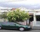
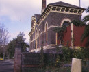
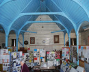
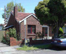
Linton developed with the usual mix of public, commercial and private buildings and has many layers of development along its main street. Wishart's blacksmith's forge, 95 Sussex Street at the south-western end of the town, is a rare survivor. A temporary branch of the Bank of New South Wales opened on 12 June 1860, in a tent located at the first diggings. The branch then moved to temporary premises in the new township and the Bank purchased land there in 1861. The first permanent building was soon extended and the attached residence was erected in 1872. The Bank moved again when it relocated to new premises at 57 Sussex Street in 1907. The first manager was Samuel Lewers who continued to be an important citizen of the town and the Shire. Murrell's Victoria Hotel, across the Creek from the Edinburgh Mine, was demolished for the post World War 2 bungalow, The Gables, at 3017 Glenelg Highway. Only the later Railway Hotel survives at 71-73 Sussex Street, a rare example of a hotel in the Gothic Revival style and unusual for not being situated on a corner, both explained by its origin as Luth's store. The railway service opened in 1890 and was extended to Skipton in 1916 but none of the infrastructure survives. Many shop buildings survive especially from the later nineteenth century, such as the handsome, former Verdoorn's butcher's shop, originally Shepherd's grocery and hardware store, at 76 Sussex Street. The shop and dwelling at 64 Sussex Street was a glove-maker's, as well as a general haberdashery shop. Nelson's Undertakers occupied the early twentieth century residence at 69 Sussex Street. Newer buildings represent later phases in the development of Linton such as former service stations and the County Fire Authority building at 77 Sussex Street. Other important buildings were located away from the main street, especially on the more prestigious higher ground. The first school opened in 1856 in a Church of England building with others to follow elsewhere but closed when the present Linton State School No. 880 opened in 1867. St Paul's Anglican Church, in the simple Early English Gothic Revival style, is the oldest surviving church. It was surrounded by a pinetum. The Methodist Church is located near the Anglican Church and dates from 1913. It was designed by the young Melbourne architect, A. S. Eggleston who went on to design many important Methodist churches. Linton has been a centre for local government since 1864. The Shire of Grenville Offices opened in 1865. These were replaced in the 1939 by the present building designed by L. H. Vernon, Shire Engineer. Other than the Post Office at 59 Sussex Street, little remains of the colonial government's administrative infrastructure following the demolition of the original courthouse and the police station complex. Many residential buildings, none of any great pretension but some with substantial period gardens, are located along Sussex Street and in the surrounding streets. Perhaps the most important survivor in Linton is the Public Library at 67 Sussex Street, which retains its rare collection of books, archives and memorabilia.
The township of Linton remains substantially intact and the surviving buildings and infrastructure from a range of periods retain a high degree of integrity. Most buildings are in good condition and important urban elements survive such as the standpipe and stone and brick gutters at the southern end of the town. A simple granite memorial to the pioneers of the district, recognising their intangible heritage, was erected on the north-east side of the main street in 1939.
How is it Significant?
The township of Linton is of historical, architectural and social significance to the Golden Plains Shire.
Why is it Significant?
The township of Linton is of historical significance as one of the many small settlements in the Shire established on the site of gold rushes in the 1850s and 1860s, several of which have survived into the twenty-first century. The former Wishart's blacksmith's shop is a rare survivor and represents a past way of life. Similarly the two surviving former Bank of NSW buildings demonstrate the changing tertiary industry of the town. Linton is of architectural significance for its range of modest building types dating from the nineteenth century, the most important of which are the Anglican, Catholic and Methodist Churches with their associated residences, many shops and their residences, the Railway Hotel (a rare example of a store converted into a hotel), the former Shire of Grenville Offices and part of the State School. Several buildings are associated with significant architects and engineers. The Linton Public Library is of particular social significance as a very rare surviving public library and collection. The township is of general social significance for its survival from a peak of several thousand, reflected in some surviving public buildings, to its modern population of several hundred. The township reflects the inter-relationship between pastoral, mining and agricultural pursuits.
-
-
Linton Precinct - Physical Description 1
The township of Linton is located on the Ballarat to Hamilton Road, now known as the Glenelg Highway, about 35 kms south-west of Ballarat. It is situated in rolling hills and straddles two branches of the auriferous Springdallah Creek. The township is generally aligned north-east to south-west and is divided by Sussex Street, which is wider than the other streets and divided in the centre of the precinct by a modern median strip. It is now the Glenelg Highway. The streets are laid out in a regular grid generally to the north-west of Sussex Street and another smaller regular grid aligned north-south to the east. The sections are not subdivided in the standard way but originally had allotments from one street to another. The allotments on the south-east side of Sussex Street are further subdivided for commercial purposes.
The Linton Heritage Precinct is located on either side of Sussex Street, bound to the north by Grant Street and to the South by the Linton - Pigoreet Road. Approaching from Ballarat, the Highway dips down towards a branch of Springdallah Creek then rises to the highest point at the shop and dwelling at 74 Sussex Street, actually the tallest and most dominant building in the town, then falls towards another branch of Springdallah Creek. Most of the commercial buildings including a former Bank of NSW (57 Sussex St), the Post Office (59 Sussex St), the Public Library (67 Sussex St) and the one surviving hotel, the Railway Hotel (71-3 Sussex St) are on the south-east side. On the north-west side are the former Shire of Grenville offices (68 Sussex St), now occupied as the Linton offices of Golden Plains Shire, an important former shop and dwelling to its north (64 Sussex St) and beyond several small stores and Traquair House, a former bank (90 Sussex St) with its Ilex sp. (Holly) and Fraxinus sp., (Ash) trees. Residences of various types and periods line the approaches, one of the more important being the former Bennett residence, an Interwar bungalow (87 Sussex St). Euphemia Wishart ran a private hospital in the small timber house at 94 Sussex Street. Wishart's former blacksmith's shop (97 Sussex St) is located at the southern end of the street with associated cottages to the south. Motor cars were originally serviced at two simple service stations (52 and 81 Sussex St).
The Historical Society is located in the former Nelson Brothers funeral director's premises (69 Sussex St). There are various memorials in the town including the Pioneer Memorial (outside 53 Sussex St), one to the Shire of Grenville, and two memorial chairs, actually cast iron and timber benches relocated from the station (outside the former shire offices, 71 and 78 Sussex St). Substantial spoon drains survive in the southern section of the road as well as a standpipe. There is a bluestone culvert in the Linton-Naringhil Road.
The roadway kinks to cross the creek and the view to the south is closed by a post WW2 bungalow, The Gables (3017 Glenelg Hwy), built on the site of the former Murrell's Victoria Hotel by Basil MacDonald in the 1950s.
Linton Precinct - Historical Australian Themes
Australian Historic Themes
The Australian Heritage Commission devised the Australian Historic Themes in 2001. The following themes have influenced the historical development of the Linton Precinct.
2. Peopling Australia
2.2 Adapting to diverse environments
2.4 Migrating
2.4.2 Migrating to seek opportunity
2.4.5 Changing the face of rural and urban Australia through migration
2.5 Promoting settlement
3 Developing Local, Regional And National Economies
3.3 Surveying the continent
3.3.3 Prospecting for precious metals
3.3.5 Laying out boundaries
3.4 Utilising natural resources
3.4.3 Mining
3.6 Recruiting labour
3.7 Establishing communications
3.7.1 Establishing postal services
3.7.2 Developing electric means of communication
3.8 Moving goods and people
3.8.5 Moving goods and people on land
3.8.6 Building and maintaining railways
3.8.7 Building and maintaining roads
3.10 Integrating people into the cash economy
3.12 Feeding people
3.12.2 Developing sources of fresh local produce
3.12.5 Retailing foods and beverages
3.18 Financing Australia
3.18.2 Banking and lending
3.19 Marketing and retailing
3.20 Informing Australians
3.20.1 Making, printing and distributing newspapers
4 Building Settlements Towns And Cities
4.1 Planning urban settlements
4.1.1 Selecting township sites
4.2 Supplying urban services (power, transport, fire prevention, roads, water, light and sewerage)
4.3 Developing institutions
4.5 Making settlements to serve rural Australia
4.6 Remembering significant phases in the development of settlements, towns and cities
5 Working
5.1 Working in harsh conditions
5.1.2 Coping with dangerous jobs and workplaces
5.6 Working in the home
5.8 Working on the land
6 Educating
6.1 Forming associations, libraries and institutes for self-education
6.2 Establishing schools
7 Governing
7.6 Administering Australia
7.6.1 Developing local government authorities
7.6.3 Policing Australia
7.6.12 Conserving Australia's heritage
8 Developing Australia's Cultural Life
8.6 Worshipping
8.6.1 Worshipping together
8.6.2 Maintaining religious traditions and ceremonies
8.6.4 Making places for worship
8.7 Honouring achievement
8.8 Remembering the fallen
8.12 Living in and around Australian homes
8.14 Living in the country and rural settlements
8.10.4 Designing and building fine buildings
Linton Precinct - Integrity
The township of Linton remains substantially intact and the surviving buildings and infrastructure from a range of periods retain from a good to a high degree of integrity. Key public buildings, open public spaces and surviving examples of commercial and residential development provide a clear sense of past and present settlement.
Linton Precinct - Physical Description 2
Contributory elements located in the proposed Linton Heritage Precinct:
The Gables, 3017 Glenelg Highway Linton
St Paul's Church of England, 2 Grantley and Gillespie Street Linton
Church of England Hall, 4 Grantley Street Linton
Former Methodist Manse, 8 Grantley Street Linton
Methodist Church, 10 Grantley Street Linton
Timber Cottage, 12 Grantley Street Linton
House, 46 Sussex Street Linton
House, 50 Sussex Street Linton
Motor Garage, 52 Sussex Street Linton
Pioneer Memorial, 53 Sussex Street Linton
House, 53 Sussex Street Linton
Gallery, 54 Sussex Street Linton
House, 55 Sussex Street Linton
House, 56 Sussex Street Linton
House (Former Bank of NSW), 57 Sussex Street Linton
House, 58 Sussex Street Linton
Murrell's Newsagency (former Boot Shop), 59 Sussex Street Linton
Shops, 61- 63 Sussex Street Linton
Shop and House, 64 Sussex Street Linton
House, 65 Sussex Street Linton
Linton Public Library, 67 Sussex Street Linton
Former Shire of Grenville Offices and War Memorial, 68 Sussex Street Linton
Historical Society Resource Centre, 69 Sussex Street Linton
Memorial Chairs, 71 & 78 Sussex Street Linton
Railway Hotel (Luth's Building at Rear), 73 Sussex Street Linton
Shop, 74 Sussex Street Linton
Shop, 75 Sussex Street Linton
CFA Building , 77 Sussex Street Linton
General Store, 80 Sussex Street Linton
House (Former Service Station), 81 Sussex Street Linton
House and Workshop, 85 Sussex Street Linton
House (former Bennett Residence), 87 Sussex Street Linton
Shop (Former Ching's Grocery), 88 Sussex Street Linton
Shop, 89 Sussex Street Linton
Traquair House, Holly and Golden Ash Trees (Former Bank), 90 Sussex Street Linton
House, 92 Sussex Street Linton
Euphemia Wishart's Private Hospital, 94 Sussex Street Linton
Cast Iron Water Stand Pipe, 97 Sussex Street Linton
Blacksmith's Shop, 97 Sussex Street Linton
Heritage Study and Grading
Golden Plains - Golden Plains Shire Heritage Study Phase 2
Author: Heritage Matters P/L
Year: 2009
Grading:
-
-
-
-
-
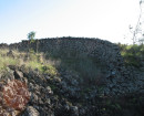
EDINBURGH CO NO.2 SHAFTVictorian Heritage Inventory
-
PIONEER COVictorian Heritage Inventory
-
EDINBURGH OR GOLDEN AGE COVictorian Heritage Inventory
-
-