Meredith Precinct
MEREDITH, Golden Plains Shire
-
Add to tour
You must log in to do that.
-
Share
-
Shortlist place
You must log in to do that.
- Download report
Statement of Significance
What is significant?
The township of Meredith is located on the Midland Highway, an equidistant of approximately 45 km south of Ballarat and north of Geelong. It is situated on a plateau, which is generally flat, falling away to the east and north as it drops towards the Coolebarghurk Creek. It is aligned north-south to east-west, with the streets laid out in a conventional grid on either side of the Midland Highway. Meredith was surveyed in 1851/2, following the discovery of gold in the districts surrounding the township. It became an important service centre for travellers between the Ballarat goldfields and the port of Geelong. The former Meredith Police Paddock, which was the region base for the Mounted Police Troup, responsible for escorting gold found within the nearby Steiglitz goldfields, was established adjacent to the track. The Midland Highway, which runs through the centre of the township, now serves as the primary route connecting Meredith with Ballarat and Geelong. Meredith developed during the gold-rush years as a civic and commercial centre servicing mining communities as well as surrounding pastoral properties. Its prominence was reinforced by the construction of the Meredith Railway Station along the Ballarat to Geelong Railway line in 1862.
A large number of stores, many of which survive, at least five hotels, of which two survive, the former Meredith Hospital, the Shire Offices, the Meredith State School and two churches survive from this period. During the post-gold rush years, the township continued to prosper as the center of a farming district that became important for its production of some of Victoria's finest Merino wool. A number of significant buildings were constructed in the early twentieth century, including the Meredith Mechanics Institute now the Meredith Memorial Hall, the Anglican Church of the Epiphany and the former Presbyterian Church, now the Uniting Church. Residential development is dispersed within the township grid and is characterised by its cottage form and scale, traditional gardens, with limited subdivision of the original allotments.
The township of Meredith remains substantially intact and the surviving buildings and infrastructure from a range of periods retain a high degree of integrity. Most buildings are in good condition, for example the shops and associated residences, which survive along Staughton Street. An avenue of Ulmus procera (English Elm), interplanted with Eucalyptus specimens run the length of Staughton Street between Wallace Street and McLeod Street.
How is it significant?
The township of Meredith is of historical, architectural and social significance to the Golden Plains Shire.
Why is it significant?
The township of Meredith is of historical significance as one of the earliest settlements established along the major trade route linking the port of Geelong to the interior of Victoria and the Ballarat Goldfields. Surviving buildings and civil infrastructure also reflect its prominence as an important civic and commercial centre servicing the nearby Steiglitz goldfields and surrounding pastoral properties. Meredith is of architectural significance for its range of building types dating from the nineteenth and early twentieth centuries, the shops surviving along Staughton Street and various private residences. Meredith is of social significance as the focus of community activity and as a representation of the inter-relationship between pastoral, mining and agricultural industries.-
-
Meredith Precinct - Physical Description 1
The township of Meredith is located on the Midland Highway, an equal distance of approximately 45 km south of Ballarat and north of Geelong. It is situated on a plateau, which is generally flat, falling away to the east and north as it drops towards the Coolebarghurk Creek. The township is aligned north -south to east - west, with the streets laid out in a conventional grid on either side of the Midland Highway.
The Meredith Heritage Precinct is located on either side of Staughton Street, bound to the west by McLeod Street and to the east by the Coolebarghurk Creek. Staughton Street is lined with an avenue of Ulmus procera (English Elm), featuring inter-plantings of Eucalyptus species, which run between Wallace Street to the railway crossing at McLeod Street. It features deep stone-lined gutters.
Most of Meredith's commercial and civic buildings are located in Staughton Street including the former Shire Hall (31 Staughton Street) which is the second hall constructed on the site and now used as a kindergarten. It is a symmetrical, single-storey bluestone building with sandstone dressings. It uses 'muscular' Gothic details including columns and half columns to create a porch in the central pavilion. A large oeuil-de-boeuf fills the gable. The Royal Hotel (20 Wallace Street), is a low timber building with a large and small gable and a modern timber verandah. The former billiard room (20 Wallace Street), addressing Staughton Street, is located at the rear of the hotel and is clad with asbestos cement sheeting.
An intact complex of late Victorian, vernacular timber shops survives along the northern side of Staughton Street. They include: timber shops (30 Staughton Street); the former bakery, an Interwar bungalow (32 Staughton Street); Mayo's Railway store and attached residence and the former Atlantic Depot (48 Staughton Street) an industrial building clad with corrugated iron. The former Post Office (58 Staughton Street) is a distinctive early twentieth century building comprising the post office, with its slightly recessed entrance trimmed with cast iron, and a residence with a timber and cast iron verandah. An extra room has now been added in front of the residence and incorporates the western end of the verandah, with a large modern window addressing the street. The post office section has some simple references to the Federation style, especially in its half-timbered gable but also continues the simple Italianate details of the residence. On the southern side of Staughton Street is Synot's shop (43 Staughton Street), a timber clad shop front and large industrial shed with a detached Victorian weatherboard residence. The Meredith Hotel (51 Staughton Street) is an Interwar weatherboard building with end pavilions, a central portico supported by a pair of Tuscan columns and a shallow pitched roof. The Meredith Memorial Hall, the former Mechanics Institute (59-61 Staughton Street) is located at the western edge of the township grid.
Wallace Street intersects with Staughton Street towards the eastern boundary of the township grid. The General Store (17 Wallace Street) is located on the corner of Wallace and Staughton Streets. It is a single storey timber building with a canted corner entrance and early shop windows. It has an attached residence with reconstructed timber post-supported verandah. Further along Staughton Street is Maygrove House (24 Staughton Street) a Federation cottage and Eclipse Cottage (22 Staughton Street) which has a significant Brachychiton populneus (Kurrajong) planted at the rear. The former Meredith Hospital (21 Staughton Street) is located on the southern side of Staughton Street, and is now much altered and used as a private residence. It overlooks the Coolebarghurk Creek.
The RSL Hall, a former army hut and War Memorial (22 Wallace Street) are located on the western side of Wallace Street. The Meredith Roadhouse (26 Wallace Street) is situated on the corner of Wallace and Wilson Streets, the southern boundary of the precinct. It is now much altered, has double gables and an encircling post-supported verandah. A small timber cottage (20 Wilson) survives on the corner of Wilson and Read Streets.
Meredith Precinct - Historical Australian Themes
The Australian Heritage Commission devised the Australian Historic Themes in 2001. The following themes have influenced the historical development of the Meredith Precinct.
2. Peopling Australia
2.2 Adapting to diverse environments
2.5 Promoting settlement
3 Developing Local, Regional And National Economies
3.3 Surveying the continent
3.3.4 Looking for land with agricultural potential
3.3.5 Laying out boundaries
3.5 Developing primary production
3.5.1 Grazing stock
3.5.2 Breeding animals
3.5.3 Developing agricultural industries
3.6 Recruiting labour
3.7 Establishing communications
3.7.1 Establishing postal services
3.8 Moving goods and people
3.8.5 Moving goods and people on land
3.8.6 Building and maintaining railways
3.8.7 Building and maintaining roads
3.12 Feeding people
3.12.5 Retailing foods and beverages
3.26 Providing health services
3.26.2 Providing hospital services
4 Building Settlements Towns And Cities
4.1 Planning urban settlements
4.1.1 Selecting township sites
4.2 Supplying urban services (power, transport, fire prevention, roads, water, light and sewerage)
4.3 Developing institutions
4.5 Making settlements to serve rural Australia
5 Working
5.6 Working in the home
5.8 Working on the land
6 Educating
6.1 Forming associations, libraries and institutes for self-education
6.2 Establishing schools
7 Governing
7.6 Administering Australia
7.6.1 Developing local government authorities
7.6.3 Policing Australia
7.6.4 Dispensing justice
7.6.5 Incarcerating people
8 Developing Australia's Cultural Life
8.1 Organising recreation
8.1.1 Playing and watching organised sports
8.1.3 Developing public parks and gardens
8.5 Forming associations
8.6 Worshipping
8.6.1 Worshipping together
8.6.2 Maintaining religious traditions and ceremonies
8.6.4 Making places for worship
8.5 Forming associations
8.8 Remembering the fallen
8.12 Living in and around Australian homes
8.14 Living in the country and rural settlements
9 Marking The Phases Of Life
9.1 Bringing babies into the world
9.1.1 Providing maternity clinics and hospitals
9.6.2 Looking after the infirm and the aged
Meredith Precinct - Physical Description 2
Contributory elements located in the proposed Meredith Heritage Precinct:
House, 19 Lawler Street Meredith
House, 21 Lawler Street Meredith
House, 27 Lawler Street Meredith
Bluestone Gutters, Staughton Street Meredith
House (former Hospital), 21 Staughton Street Meredith
'Eclipse Cottage' and Barchychiton populneus (Kurrajong), 22 Staughton Street Meredith
'Maygrove', 26 Staughton Street Meredith
Shop (east shop of pair), 30a Staughton Street Meredith
House, 32 Staughton Street Meredith
House, 38 Staughton Street Meredith
House, 40 Staughton Street Meredith
House, 42 Staughton Street Meredith
Shop, 43 Staughton Street Meredith
House, 43 Staughton Street Meredith
House, 46 Staughton Street Meredith
Shop and Residence, 48 Staughton Street Meredith
Shed (Atlantic Depot), 48 Staughton Street Meredith
Meredith Hotel, 51 Staughton Street Meredith
House, 52 Staughton Street Meredith
Former Post Office and Residence, 58 Staughton Street Meredith
Meredith and District Memorial Hall, 61 Staughton Street Meredith
General Store and Residence, 17 Wallace Street Meredith
Royal Hotel and Billiard Room, 20 Wallace Street Meredith
RSL Hall and War Memorial, 22 Wallace Street Meredith
Meredith Road House, 26 Wallace Street Meredith
House, 20 Wilson Street Meredith
Meredith Precinct - Integrity
The township of Meredith remains substantially intact and the surviving buildings and infrastructure from a range of periods retain a high degree of integrity. Key public buildings and surviving examples of commercial and residential development provide a clear sense of past and present settlement. A network of recently erected interpretive signs provides historical background for key buildings within the township.
Heritage Study and Grading
Golden Plains - Golden Plains Shire Heritage Study Phase 2
Author: Heritage Matters P/L
Year: 2009
Grading: Local
-
-
-
-
-
MARYBOROUGH TOWN HALLVictorian Heritage Register H2152
-
SubstationGolden Plains Shire
-
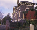
St Josephs Catholic ChurchGolden Plains Shire
-
-