Mount Martha - Mornington Foreshore
MORNINGTON VIC 3931 - Property No L10064
-
Add to tour
You must log in to do that.
-
Share
-
Shortlist place
You must log in to do that.
- Download report
Statement of Significance
What is significant?
There is physical evidence of Aboriginal use of the coast in the form of middens; most of these are damaged, and the people themselves were effectively wiped out following contact with the settlers of the Port Phillip area.
Early exploration of the area occurred in 1802 and 1803, but extensive European activity did not begin until the late 1830s. In those early days the locality was of importance for timber for Melbourne, fishing, and pastoral activity including cows and sheep.
The area then gradually became an important resort to which Melbourne people came for holidays and day trips, arriving first on steamboats, then the train and buses and, from the 1920s, by private car. The importance of the land abutting the coast was recognised early by the Council and Government, with the retention of reserves, prohibition of tree felling and development of public facilities on the foreshore.
Urban development of the land adjacent to the foreshore gained pace in the 1940s, bringing with it many pressures on the narrow strip of coastal land in the reserve.
How is it significant?
The Mornington Mount Martha foreshore is significant for aesthetic, historic, social and scientific reasons at the State level.
Why is it significant?
Within Port Phillip Bay the Mornington Mount Martha foreshore has a high relative visual quality and historical, geological, cultural and ecological interest.
Aesthetic Value
The area is recognised for its high scenic value, having significant natural vegetation together with high visual quality associated with diversity of landform.
Historical Value
The area contains several Aboriginal midden sites.
There are the remains of an early industrial activity; the lime kilns at Fossil Beach.
The pattern of development along the Bay coast reflects both the early pastoral subdivision and the subsequent provision of holiday allotments and permanent residential subdivision.
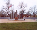
The formal park land at Schnapper Point, which overlooks Mornington Harbour, is a contrasting element which adds diversity in terms of vegetation and provides a sense of past landscape preferences. Its stone walls, often prominent behind the beach, generally add visual variety and a sense of the past to the landscape. There are two memorials to Matthew Flinders (a statue and a cairn). There is also a memorial to the 15 Mornington footballers who drowned on the return trip to Mornington after a game at Mordialloc on 21 May 1892.
Scientific and Educational Value
Mount Martha cliffs, Mornington to Frankston cliffs, Fossil Beach and Balcombe Bay are of geological interest, with a variety of geological structures and formations and fossil deposits.
Social Value
The area is renowned as a recreational location near Melbourne and is heavily used in summer for beach related activities. The Mornington - Mount Martha coast is also the focus of much private boating activity, and there is some commercial tourist and fishers' use of the area, at Mornington.
LOCATION:
A length of coastline within the Mornington Peninsula Shire, located about 55 to 75 km south of Melbourne by road.
The area comprises Crown land on the coast of Port Phillip Bay.
-
-
Mount Martha - Mornington Foreshore - Physical Description 1
Geology and Geomorphology
At the northern end of the classified area, the granodiorite shore comes to an end and sandy beaches, similar to those further north at Moondah and Sunnyside, resume. They are coves separated by cliffed outcrops of Baxter Sandstone (Schnapper Point, Linley Point).
Then Baxter Sandstone forms high promontories and cliffs, with fallen sandstone hardened into ironstone. Balcombe Clay is at the base of the cliffs. Fossil Beach is named for the Miocene fossils occurring in this clay. To the south there are horizons of coarse and fine sandstone beneath the Balcombe Clay. (Gostin 1966, Jenkin 1988). At Harmon Rocks the underlying Older Volcanics again rise above sea level and form a small cliffed promontory, exposing much-weathered basalt with joints filled by ironstone carried down from the overlying Baxter Sandstone. The shore is strewn with angular blocks and rounded cobbles of basalt.
In Balcombe Bay there have been landslides where the Baxter Sandstone has subsided over slippery Balcombe Clay to form irregular tumbled coastal slopes (Gostin 1973). The sandy beach continues past the mouth of Balcombe Creek, which flows into a reedy and scrub-fringed lagoon often cut off from the sea by a wave-huilt sand barrier, and there are usually at least two nearshore sand bars, varying in position and depth with wave conditions.
The Balcombe Bay beach ends against cliffs of weathered granodiorite, which have a shore platform consisting of a wave-cut (abrasion) ramp. The upper slopes are cut in weathered granodiorite, but the cliffs have an irregular outline, with ribs and clefts dropping steeply below low tide level to a sandy sea floor close inshore. The absence of sandy beaches along the rocky Mount Martha coast may be due to the steep profile, which reflects wave action and has prevented intertidal (shore) sand accretion.
The rocky coast continues past Martha Point, where the steep slopes decline to low cliffs and the bordering abrasion ramps reappear as the more weathered granodiorite zone descends again to sea level. There are pebble beaches derived from the adjacent cliffs and shore platforms where the rocks are closely jointed and weather into small angular fragments. Then there is an apron of Late Pleistocene to Holocene brown and grey gritty clays washed down the southern slopes of Mount Martha to Safety Beach.
(The above text draws on Bird,ECF, The Coast of Victoria: The Shaping of Scenery. Melbourne University Press, 1993, with the author's permission)
Vegetation
(After Calder , W B Peninsula Perspectives . Jimaringle Publications 1986 and Vantree Pty Ltd, Frankston to Mount Martha; Coastal Processes and Strategic Plan. November 1996)
The original vegetation of this coastal strip was primarily banksia - she-oak open forest, backed by eucalyptus (principally coastal Manna Gum, Eucalyptus viminalis ssp pryoriana) woodland to open woodland (Calder , W B Peninsula Perspectives . Jimaringle Publications 1986). Over time, man's impact has removed much of the original she-oaks and prevented regeneration of both banksia and she-oak. They have been replaced with common tea tree (Leptospermum laevigatum) and introduced weeds.
The main vegetation types are now "tea tree scrub" and "banksia woodland", with a number of other communities with a more restricted distribution. These include Stipa grassland, Poa grassland, Themeda grassland, Spinifex grassland, Saltbush shrubland, Noon-head herbland, reed grassland, sub-saline marsh and salt marsh (Vantree Pty Ltd, Frankston to Mount Martha; Coastal Processes and Strategic Plan. November 1996).
Much of the coastal vegetation is invaded by weed species, many of them garden escapes. They include boneseed (Chrysanthemoides monilifera), soursob (Oxalis pes-caprae), myrtle leaf milkwort (Polygala myrtifolia), box thorn (Lycium ferocissimum), bridal creeper or smilax (Asparagus asparagoides), New Zealand mirror bush (Coprosma repens) and radiata pine (Pinus radiata).
There is a lack of regeneration of indigenous species together with the ageing of existing vegetation. User pressure on coastal sites, lack of natural processes such as fire, and the effects of runoff, erosion and weed invasion mean that little natural regeneration can occur.
Fauna
Fauna records for the coastal strip from Tassells Creek to Beleura Hill show that the principal area from which records have been obtained is the vicinity of the Balcombe Creek estuary. Mammals recorded near the estuary include: short beaked echidna (Tachyglossus aculeatus), agile antechinus (Antechinus agilis), common brushtail possum (Trichosurus vulpecula), common ringtail possum (Pseudocheirus peregrinus), sugar glider (Petaurus breviceps), feathertail glider (Acrobates pygmaeus), koala (Phascolartcos cinereus) and swamp rat (Rattus lutreolus). Mammal records for the estuary also include the introduced house mouse (Mus musculus), European Rabbit (Oryctolagus cuniculus), feral cat (Felis catus) and red fox (Canis vulpes). Marine mammals sighted in the vicinity of this coastline have included Australian fur seal (Arctocephalus pusillus), southern right whale (Eubalaena australis), killer whale (Orcinus orca) and common dolphin (Delpinus delphis). The echidna has also been recorded near Mills Beach and the white-striped freetail bat (Tadarida australis) near Schnapper Point.
The appendix "Fauna Species from Tassells Creek to Beleura Hill" is an extract from the Atlas of Victorian Wildlife, maintained by the Department of Sustainability and Environment. It lists the mammals, birds, reptiles, frogs and fish found in the area, together with their conservation status in Victoria.
Man-made elements
Structures abound on the coast.
The bay coast of the Peninsula is notable for bathing boxes, which were popular in the 19th and early 20th centuries. Most of these in the classified area are on Crown land. They were built principally at Mills and Mothers Beaches at Mornington and at the Mount Martha North beach. The Department of Sustainability and Environment and the Mornington Peninsula Council offer only limited opportunities for replacement of damaged bathing boxes. A healthy real estate market for bathing boxes has formed.
There are the usual life saving club buildings, public toilets and changing rooms, public lighting and drains along the coast. In addition there are several usages not directly related to the coast, such as a bowling club and restaurants at Mornington.
Mornington Park is the principal formal park along this section of coast. Grassed, with large old cypresses and some more recent plantings of native trees, it has play areas, toilet facilities, and elderly citizens' club, car and bus parks, picnic facilities and access to the beach via asphalt paved footpaths. It also has a memorial cairn for and a statue of the navigator Matthew Flinders and a memorial to the 15 footballers who drowned during the return trip from Mordialloc on 21 May 1892.
At Fossil Beach, there are the remains of the former lime kilns (Culican & Taylo
r. Fossil Beach Cement Works, Mornington 1972). This plant operated betwee
n 1862 and 1864. The site is listed on the inventory of Heritage Victoria (site 7921-21) and is said to be highly significant as an early example of a Victorian coastal industrial works.
CONTEXT:
The area is a continuous coastal strip bounded by the sea on one side and busy road with a nearly fully developed suburban residential environment on the landward side. There are some minor breaks in the residential pattern, particularly at the mouth of Balcombe Creek in Mount Martha (where there is a Crown reservc) and along the coast road between Tassells Creek and Martha Point, where for most of the distance the terrain is hilly and vegetation remains on the freehold land, and consequently development is more remote from the coastal reserve, or is more screened than elsewhere.
The area shares the "highest scenic value" rating with the landscape of the heads to Port Phillip Bay, (Port Phililp Authority, Port Phillip Coastal Study. 1977). The area south of Schnapper Point was designated as having "Significant Natural Vegetation", high visual quality with strongly contrasting and high relative diversity of landform. Naturalness is high and undesirable visual impacts of man made development are generally reduced by good indigenous vegetation cover. The vegetation is diverse, ranging from exposed cliffs to more sheltered clifftop and low lying associations. (Port Phillip Authority, Coastal Vegetation of Port Phillip Bay. 1982).
The Esplanade is a narrow road running along the cliff tops and the undulations and bends in the road enable fine vistas of the foreshore and Bay to be obtained. This road is an outstanding scenic road, providing one of the most attractive coastal driving experiences along Port Phillip Bay.Mount Martha - Mornington Foreshore - Intactness
Little if any of the coastal reserve is "intact". The vegetation has been disturbed and exploited over the past century and a half. There are many coastal works and structures such as tracks, sea walls, bathing boxes, toilet and changing facilities, lights, clubhouses. There is significant weed invasion along all of the reserve. There is erosion and one or two unstable cliff areas.
However, there is much that has been retained and that is still relatively unspoiled. Many of the views along the coast are dramatic and little changed over time. There is still substantial indigenous vegetation and the possibility exists for it to be improved through suitable management.
-
-
-
-
-
COMBE MARTINVictorian Heritage Register H1900
-
FORMER MORNINGTON BATHSVictorian Heritage Inventory
-
Former ClifdenNational Trust
-
-