Back to search results
230 Union Road
230 Union Road SURREY HILLS, BOROONDARA CITY
Union Road Residential Precinct HO534
230 Union Road
230 Union Road SURREY HILLS, BOROONDARA CITY
Union Road Residential Precinct HO534
All information on this page is maintained by Boroondara City.
Click below for their website and contact details.
Boroondara City
On this page:
Statement of Significance
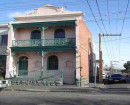
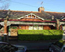
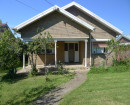
HO534 Union Road Residential Precinct, Surrey Hills What isSignificant?Union Road Residential Precinct in Surrey Hills is boundedby WhitehorseRoad to the north and Guildford Road and Montrose Street tothe south.Properties in the precinct occupy both sides of the road,which gentlyslopes upwards from the south to the north. Dwellings ofheritage valuepredominantly fall into two distinct phases ofdevelopment, theFederation period of nominally 1910-1915; and theinterwar period of the1920s, 1930s and early 1940s. There are also somehouses of the late1880s and early 1890s, reflecting earliersubdivisions, including thestimulus provided by the railway's arrival atSurrey Hills in 1882.Within the precinct, brick dwellings are mostcommon, althoughweatherboard houses of the Federation and interwarperiods are alsofound. There are also a number of substantial brickresidences, ongenerous allotments, which reflect a common pattern (inBoroondara) ofconstructing large dwellings on main or principal roads.Both sides ofUnion Road were virtually fully developed by the advent ofWorld WarTwo, with little subsequent development until the latertwentiethcentury when infill dwellings replaced some of the earlierbuildings.The precinct comprises a high number of properties which haveare graded'contributory', with relatively few graded 'significant'. Howis itSignificant? Union Road Residential Precinct is of historicalandaesthetic/architectural significance to the City of Boroondara. Whyisit Significant? Union Road Residential Precinct is of localhistoricalsignificance, as a long-standing residential area concentratedin UnionRoad, which demonstrates aspects of the growth and consolidationofSurrey Hills from the latter decades of the nineteenth centurythroughto the interwar period. Development generally commenced in the1880safter the extension of the railway line to Lilydale and theconstructionof the railway station in 1882. However, as with other areasof SurreyHills, development was stymied by the 1890s economicDepression, andthen picked up again after the extension of theWhitehorse Road tramwayin 1916. Following another halt during World WarI, developmentintensified and consolidated in the interwar period.Although not alarge precinct, Union Road is also significant forreflecting the rangeof development which could occur on principal ormain roads in what was,historically, an outer urban area. This includesa piecemeal pattern ofdevelopment on earlier large allotments, whichwere later re-subdividedfor more intensive urban development; thesurvival of earlier land usesuntil the interwar period, such as themarket garden and dairy on thewest side of Union Road; the constructionof larger dwellings, as ismore common on main roads; and the inclusionof buildings which were notstrictly residential, such as the doctor'ssurgery and residence at 174Union Road, the Anglican Church property at175-177 Union Road, and theconvalescent home at 257-59 Union Road. UnionRoad Residential Precinctis also of local aesthetic/architecturalsignificance. The precinct,which predominantly comprises dwellings fromthe Federation and interwarperiods, has a comparatively high level ofintactness in terms of itshistorical development. Typical, and valued,Federation characteristicsof dwellings include external wall materialsof weatherboard with eitherhalf-timbered and stucco panels, orcontinuously stuccoed gabling; thereturn verandah and corner entry'diagonal' form; tall chimneys; andsome houses with short verandahsplaced between projecting wings.Double-hung sash windows are common;there are also hinged casements,shallow box-frame and canted baywindows. Interwar development islargely concentrated on the west side ofUnion Road. Its principal, andvalued, characteristics include bungalowsmarked by breakfront wings orprojecting brick porches, with a lowhorizontal emphasis and hippedroofs. Several have a full-size gable, andporches integrated withrooms. Other characteristics includestucco-covered brick walling, astuccoed frieze to the upper face-brickwalls, and extensive red orclinker face-brick walling. Transverse-roofbungalows, with accentuatedhorizontal forms, are also found. Laterinterwar houses in the precinctgenerally avoid gables, replacing thesewith hipped breakfronts; thelater dwellings are also marked by the useof clinker or cream brick,relieving tapestry brick, and again anemphatic horizontal emphasis.
Show more
Show less
-
-
-
-
Ingoda
 Boroondara City
 -
House (formerly Surrey College, Norton)
Boroondara City
-
Guilford (Monserrat)
Boroondara City
-
-