Union Road Residential Precinct HO534
Union Road SURREY HILLS, BOROONDARA CITY
-
Add to tour
You must log in to do that.
-
Share
-
Shortlist place
You must log in to do that.
- Download report
Statement of Significance
What is Significant
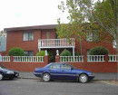
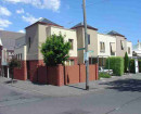
Union Road South Residential Precinct, Surrey Hills, is located between Canterbury Road to the north and Riversdale Road to the south, Union Road to the west and The Avenue to the east. The precinct, in two main areas, comprises 'significant' and 'contributory' dwellings from the 1880s through to early 1940s, and has a comparatively high level of intactness. Properties included in the precinct are concentrated along and to the east side of Union Road in the northern section of the precinct. In terms of the topography, the precinct slopes down from the north to the south with, as a general pattern, larger and older houses at the north end and smaller and more modern dwellings further south. In the higher areas of Union Road, houses are also often elevated off the ground, which enhances their presentation and prominence. A large number of dwellings are of timber, a building material which is characteristic of Surrey Hills; there are also brick buildings in the precinct. In terms of the eras and styles of development, there are two main periods albeit with intervening bursts of building activity. They are the late Victorian and Federation periods of development, following the initial land sales of the 1880s which resulted in houses being built from the 1880s (a limited number) into the 1890s to 1910s; then the second major phase of development following World War One with houses in the precinct dating from the 1920s through to c.1940 (and effectively the early years of World War Two, prior to the 1942 ban on non-essential construction).
How is it Significant
The Union Road South Residential Precinct is of historical and aesthetic/architectural significance to the City of Boroondara.
Why is it Significant
The Union Road South Residential Precinct is of historical significance, as a long-standing residential area in Union Road, Surrey Hills, which demonstrates aspects of the growth and consolidation of Surrey Hills from the latter decades of the nineteenth century through to the later interwar period. Development generally commenced in the 1880s after extension of the railway line to Lilydale and the construction of the railway station in 1882. However, as with other areas of Surrey Hills, the 1890s economic Depression stymied development, which then picked up again after the extension of the Riversdale Road tramway through to Wattle Park in 1916 and the cessation of World War I, with development intensifying and consolidating in the interwar period. Land in the precinct was promoted in early estate subdivisions as being especially 'picturesque', a result of the topography of the precinct, and the elevated siting of the east side of Union Road in particular. The precinct is also notable for a concentration of larger scaled houses on generous allotments in the northern section, which in turn reflects a pattern which is common in Boroondara, of establishing substantial properties on main or principal roads.
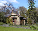
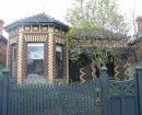
Union Road South Residential Precinct is also of aesthetic/architectural significance. Victorian houses are generally in the Italianate manner with L-shaped plans; iron verandah friezes; verandah roofs separated from the main hipped and slate-clad roofs; corniced chimneys; and some timber ashlar fronts on weatherboard examples. Federation architecture is represented in houses at the north end of Union Road and in The Avenue, and displays some typical characteristics of the genre including a dominant main roof often with an integral verandah roof; diagonal planning; return verandahs; and an accentuated corner bay or tower bracketed by two or more wings projecting at right angles. More numerous in the precinct are Bungalow designs and later interwar housing, which also display typical characteristics such as horizontal proportions; square plans with a corner 'cut outs' to provide for a porch-verandah; side entries set well back on the site; and main transverse gable roofs, sometimes with a gabled wing to the front. Later interwar houses in the precinct have simplified Tudor elements in clinker and tapestry brick, with some cement render; brick gable fronts with boxed eaves; steeper roof pitches than seen with the Bungalows; slender chimneys with no pots and often without verandahs.
Grading and Recommendations
Recommended for inclusion in the Schedule to the Heritage Overlay of the Boroondara Planning Scheme as a precinct.
For a full list of individual place gradings within the precinct, please refer to the attached PDF citation, or individual child records attached to this parent record.
-
-
Union Road Residential Precinct HO534 - Physical Description 1
[See also 'Architectural & Comparative Analysis' below.]
The Union Road Residential Precinct is bounded by Whitehorse Road to the north and Guildford Road and Montrose Street to the south. Properties in the precinct occupy both sides of the road, which gently slopes upwards from Guildford Road and Montrose Street to the north. The precinct is generally contiguous, with the exception of some small concentrations of infill, multi-unit and dual occupancy development at 219-227 Union Road, which have been excluded from the precinct boundaries.Dwellings of heritage value in the precinct predominantly fall into two distinct phases of development - the Federation period, in the years leading up to the outbreak of the First World War, nominally the 1910-1915 period; and the interwar period with a surge of residential development during the 1920s and then from the early 1930s gradually slowing and ceasing in the early years of the Second World War There are also some earlier houses, constructed in the late 1880s and early 1890s, including the single storey block-fronted timber Victorian villa Mintaro (215 Union Road 'contributory'); Allan Brae (195 Union Road, 'contributory'); and the tuck-pointed brick villa Tavistock (192 Union Road, 'contributory').
Interwar development is largely concentrated on the west side of Union Road, with the section between Whitehorse Road and Weybridge Street being an area which, as noted in the 'History', remained in use as a market garden and dairy until well after the First World War when the land was subdivided. Primarily, the houses built here were subsequently either weatherboard Californian bungalows or single storey brick villas of pink-orange face brick and clinker brick.
An institutional building in the precinct - the rendered brick purpose-built mid-1930s convalescent home Holmsdale (257-59 Union Road 'contributory') - is located on the east side of the road, adjoining Whitehorse Road to the north. Nos 216 - 218 Union Road ('contributory') are nearidentical c. 1941 single-storey triple-fronted brick villas which incorporate brick garages in the body of the house. No 218 also Union Road also retains its original brick fence.
Within the Union Road Residential Precinct the majority of the properties are of 'contributory' heritage value, with several also identified as 'significant' (see the Schedule of Properties which accompanies this citation).
Properties of 'significant' heritage value are defined in Boroondara's Clause 22.05 'Heritage Policy' as follows:
'Significant' heritage places are individually important places of State, municipal or local cultural heritage significance. They can be listed individually in the Schedule to the Heritage Overlay. They can also be places that, when combined within a precinct, form an important part of the cultural heritage significance of the precinct. They may be both individually significant and significant in the context of the heritage precinct.
The 'significant' buildings are generally individually important in the precinct context, because they exhibit particular architectural merit or other notable and distinguishing characteristics. They are also typically highly intact, with few if any visible external changes (as seen from the principal streetscape). The 'significant' buildings are described and referred to below.
Properties of 'contributory' heritage value are defined as:
'Contributory' heritage places are places that contribute to the cultural heritage significance of a precinct. They are not considered to be individually important places of State, municipal or local cultural heritage significance, however when combined with other 'significant' and/or 'contributory' heritage places, they play an integral role in demonstrating the cultural heritage significance of a precinct.In this precinct, the 'contributory' value of the properties generally derives from the 'contribution' they make to the overall heritage character of the precinct. This includes generally retaining the fabric, form, detailing and largely original external appearance (as visible from the principal streetscape) of buildings constructed in the two major phases of development which distinguish the precinct, being the Federation-style dwellings of the (approximate) 1910-1915 period, and the interwar houses of the 1920s, 1930s and early 1940s. Some (limited in number) 'contributory' buildings also fall outside this range. For 'contributory' buildings, some additions may also be visible including potentially large additions to the rears (or rear halves) of dwellings; minor changes to the principal facades of these dwellings may also be evident.
More recent infill development in the precinct, and some earlier buildings which have been significantly modified, or have undergone substantial alterations including large and prominent additions to the front halves of dwellings, have been identified as 'non-contributory': 'Non-contributory' places are places within a heritage precinct that have no identifiable cultural heritage significance. They are included within a Heritage Overlay because any development of the place may impact on the cultural heritage significance of the precinct or adjacent 'significant' or 'contributory' heritage places.
The Holy Trinity Anglican Church property at 175-177 Union Road, comprises several buildings. These include the Federation-style vicarage (Figure 16), and the hall and church buildings constructed in the early twentieth century. While the vicarage is 'contributory', and the whole of the historic church property is shown as 'contributory' in the precinct map, the hall and church buildings have undergone significant modifications and additions, which have impacted on their historic presentation and original form. The latter buildings are therefore not 'contributory', due to their poor level of intactness.
Within the precinct, buildings constructed of brick are most common, apart from a sequential row of Californian bungalows on the west side of Union Road north of Weybridge Street (222-238 Union Road, all 'contributory' apart from 226 Union Road which is 'non-contributory'); and a row of residences, the majority of which are Federation era dwellings, on the east side of Union Road (237-245 Union Road, all 'contributory' apart from 237 Union Road which is 'significant', and 241 and 245 Union Road which are 'non-contributory'). 237 Union Road gains distinction in that it was built by a local builder Albert George Harbert for his own use, and has been continuously occupied by his family since its construction in c. 1913-14. 12 Non-consecutive examples within the p recinct include a recently renovated Federation villa (180 Union Road, 'contributory'); and a Californian bungalow (253 Union Road, 'contributory').There are a number of substantial brick residences, set on generously sized allotments, two of which are graded 'significant'. These include the aforementioned residence/surgery to 174 Union Road, and 181 Union Road (both graded 'significant'); and the partially concealed houses at 195, 198, 199, and 210 Union Road (all 'contributory'). Typically these are set well back from the street frontage, and in the case of 198 Union Road, are largely hidden by the fall of the land. Both of the 'significant' properties, and in particular 174 Union Road, retain a high degree of intactness, with the latter virtually unchanged since the 1930s (compare Figure 7 and Figure 8). These larger dwellings also reflect a pattern which is common in Borooondara, of constructing large dwellings on generous allotments on main or principal roads.
Properties in the precinct are, in the main, single home allotments. There has been comparatively little multi-unit development in this section of Union Road; those properties where this has occurred have generally been excluded from the precinct area.
Properties in the precinct have generally been maintained in good repair. Several have high fences, as is again common with busier roads, variously of face or rendered brick; low dwarf walls of brick are also found, sometimes with painted iron work; non-original timber picket fences are additionally found in the precinct. There are also some brick and hedge combinations; 189 and 211 Union Road both have mature cypress hedges, with the latter a finely sculpted element which adds to the significance of the residence behind.Heritage Study and Grading
Boroondara - Surrey Hills and Canterbury Hill Estate Heritage Study
Author: Lovell Chen
Year: 2011
Grading: Local
-
-
-
-
-
JEFFERIES HOUSEVictorian Heritage Register H0461
-
KinnoulBoroondara City
-
KirklandsBoroondara City
-
-