Back to search results
FORMER MCATEER FARMING COMPLEX
375-389 BARWON HEADS ROAD, CHARLEMONT VIC 3217
FORMER MCATEER FARMING COMPLEX
375-389 BARWON HEADS ROAD, CHARLEMONT VIC 3217
All information on this page is maintained by Heritage Victoria.
Click below for their website and contact details.
Victorian Heritage Inventory
On this page:
Statement of Significance
What is significant?
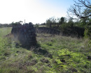
The Former McAteer Farming Complex site is located within land purchased by Frances McAteer in 1866 and occupied by the McAteer family until 1924. The site has been assessed as having moderate-high archaeological potential within sections 1 and 3, with architectural remains relating to early rural settlement and occupation by members of the McAteer family (c.1866-1924). While subsequent activities have undoubtedly resulted in subsurface disturbance (e.g. service emplacements, landscaping, rabbit burrows, roadworks), it seems likely that in situ nineteenth-century structural remains and associated deposits remain at the site (e.g. 1866 cottage, rubbish pit). Given that the c.1867 cottage appears to retain its original floorboards, it seems likely that sub-floor deposits are preserved beneath this building (GHMH 2020b: 10).How is it significant?
The Former McAteer Farming Complex site is of aesthetic, archaeological, architectural, historical, and scientific significance at a local level.Why is it significant?
The site has been assessed as having moderate-high archaeological potential, with architectural remains relating to early rural settlement and occupation by members of the McAteer family (c.1866-1924). While subsequent activities have undoubtedly resulted in subsurface disturbance (e.g. service emplacements, landscaping, rabbit burrows, roadworks), it seems likely that in situ nineteenth-century structural remains and associated deposits remain at the site (e.g. 1866 cottage, rubbish pit). Given that the c.1867 cottage appears to retain its original floorboards, it seems likely that sub-floor deposits are preserved beneath this building.Show more
Show less
-
-
-
-
NORTH MELBOURNE POTTERY
 Victorian Heritage Inventory
 -
STONY CREEK SLIPWAY
Victorian Heritage Inventory
-
SEASONING WORKS SITE AND TERRACOTTA LUMBERWALL
Victorian Heritage Inventory
-
-