JOY ALLOTMENT 21A SITE
1190 MURRUNGOWAR ROAD CABBAGE TREE CREEK, EAST GIPPSLAND SHIRE
-
Add to tour
You must log in to do that.
-
Share
-
Shortlist place
You must log in to do that.
- Download report
Statement of Significance
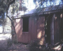
-
-
JOY ALLOTMENT 21A SITE - History
Murrungowar Settlement
The forested hills of Murrungowar were settled in the 1890s, with the promise of a railway from Orbost and access to markets for produce. Selected land was cleared for mixed farming of dairy, beef, pigs, potatoes, maize and other enterprises. A township site and farming allotments surveyed. The new farming settlement initially flourished from the early to mid 1890s. Many families selected and cleared land, built homes and began farming. In the early decades, a small community supported an upper and lower school, post office, hotel and store. It was estimated that the population of the area was approximately 100.
However, an inadequate road network and poor connections to Orbost over the Brodribb River continued into the early 20th century. Combined with the non-eventuation of the railway, many of the farms were gradually abandoned from the First World War and into the 1920s.
Historically, Murrungowar was referred to as Upper and Lower locals appear to have referred to Murrungowar Lower and Upper. It also appears there were schools in both localities.
Allotment 21a (J. Joy) Parish of Murrungowar
Historic features are located within the former Murrungowar Parish allotment, 21A, originally held by J. Joy. A search of the online historical record of Trove newspapers and Public Records Victoria shows a John and a Joseph Joy living in the Murrangowar area in the late 19th and early 20th centuries.
An in-depth history of the site has not been undertaken, however from preliminary research, it would seem that the block in question was owned by John Joy.
John Joy was one of the pioneer residents of Murrungowar. He undertook many varied activities, and was an active member of the pioneering community. In 1906, Joy had contacted Orbost Shire Council regarding an outbreak of Mayweed in the adjacent Block 20, which was rapidly spreading. He was a member of the Orbost Railway league that was lobbying action on the railway extension. He also was active in raising funds for the building of the Lower Murrungowar School. Joy’s occupation activities included farming, shearing, mining and a business in carting.
John Joy passed away at Orbost Hospital aged 84 in February 1942. His obituary claimed he was the first white man to settle at Murrungowar, where he took up land in 1882.
Like many of the selections in the locality, Block 21a appears to have been abandoned sometime in the 1920s, and would have certainly been abandoned by the time of John Joys death in 1941. Buildings on the site may have been utilised for later forestry activities.JOY ALLOTMENT 21A SITE - Interpretation of Site
The site contains a range of features and artefacts that clearly demonstrate early settlement and the opening of remote mountainous regions of Victoria during the late 19th and early 20th centuries. Features and archaeology of the site demonstrate domestic, daily life in the new farming settlement. Agricultural/framing implements demonstrate types and methods of farming practice on small scale selections. More detailed analysis of the archaeological features and historical record may reveal personal information and detail about the Joy family and their relationship to the site and the broader Murrungowar settlement and community. Post forest harvesting activity has occurred in the area, particularly on the verges of the site. B This appears to have had little impact upon the features and archaeology of the site, but has caused ground disturbance in areas outside the surveyed area. The reclaiming of remaining sites features by the regrowth of large mature eucalypt forest is a potentially evocative and powerful geographic experience of abandonment and a way of life long gone.
Heritage Inventory Description
JOY ALLOTMENT 21A SITE - Heritage Inventory Description
The site is situated upon a high point gently falling to north to Dead Horse Creek and adjoining Murrungowar Road to the south. The site is situated within the logging coupe reserve in the Murrungowar State Forest and is immediately adjacent to the 11km Marker Post on the Murrungowar Road. The concrete and granite rock fireplace footings, form the approximate centre of the site. Surrounding the fireplace footings are the artefacts and feature remains of a small farm selection dating from the late 19th, early 20th century. The site is situated within a eucalypt forest which was recently burnt during the 2019/20 bushfires. Vegetation regrowth is obscuring much of the site, with understory and ground cover vegetation obscuring the southern and eastern portions of the inspected area. The site was initially identified by Lisa Conte, VicForest, General Officer. It was inspected again for survey by Kyle Dennis, Supervising Officer, VicForests and surveyed by Andrew Swift, heritage advisor. Fireplace and Building Site: A concrete and granite footing 1420mm long, x 650mm wide and 500mm high, identify the likely position of the main dwelling/residence. No timber features remain. On the western side of the footing a recess suggests the position of sub-floor bearings and joists, whilst the eastern side forms the outside of the fireplace structure. The scale of and construction appears to have housed a wood/combustion stove or similar. There is no evidence of masonry walls or stone or brick chimney that would form a traditional fireplace. Without a detailed survey of the area, this feature alone would suggest a small and modest building, without a larger fireplace typically found in slightly larger and permanent buildings.1 The surrounding features and artefacts also strongly suggest it as the principal dwelling/residential building. In the immediate area of the fireplace footing a number of artefacts are scatted about the surface, including beer (horseshoe brand) and food storage glassware, tableware ceramic fragments and non-ferrous corroded metal plate, wire, etc. the ground has been largely disturbed by wildlife burrows and uprooted trees. The building site is situated beneath large tree ferns. Refuse and rubbish site: 40 metres to the north and west of the fireplace footing is an area were the ground gently falls to the north. Along this verge a large quantity of domestic rubbish from the late 19th, early 20th century is located. Artefacts are numerous and represent a range of domestic and food storage and tableware items. Artefacts include, brown, white and clear glass storage bottles, cast-iron stove-top kettle, laundry wash tub. Other items include parts of agricultural equipment, including harrow components, cast-iron wheels, jinker springs, and other sundry forged and cast components. Components of various other agricultural machinery extend around to the west. Much of the iron-work components are heavily corroded. Building Site, Rock Mound & Agricultural Machinery: 40 metres to the west is a low rock and earth mound approximately 3400mm long x 1400mm wide and 300mm high. This feature is located on the verge of a gentle slope falling to the north-west. The eastern side is a large flat area, suggestive of a building site. The built rock and earth mound is partially obscured by ground-cover vegetation. It doesn’t necessarily have the form of a fireplace, nor a blacksmith hearth? A few metres to the south is another large component of agricultural machinery (purpose not immediately known). A makers name on the wheel, ”W.G. BARGER MAKERS MELBOURNE, H48.”2 Rock Edging: To the south a line of five rocks suggest a boundary, or edging. Extent of Site: the features of the site are situated within a 50m radius from the fireplace footings (GDA 94: 55 H 648831 5835066). This forms a 100 metre diameter area for the extent of the site. Outside the extent of the site, the ground has disturbed in many areas by heavy machinery and past forestry activity. No historic or archaeological features were identified.
-
-
-
-
-
FINCHAM AND HOBDAY PIPE ORGANVictorian Heritage Register H2450
-
STATE GOVERNMENT OFFICES, GEELONGVictorian Heritage Register H2451
-
NORTH MELBOURNE POTTERYVictorian Heritage Inventory
-
-