DEEP CREEK INLET
INTERSECTION OF RIVER TRACK, RED RISE TRACK AND BELLS BEND ROAD, LEITCHVILLE
-
Add to tour
You must log in to do that.
-
Share
-
Shortlist place
You must log in to do that.
- Download report
Statement of Significance
-
-
DEEP CREEK INLET - History
Between 1877 and 1881 there was a severe drought which resulted in the Victorian Government passing the Water Conservation Act 1883, which provided for the establishment of Irrigation Trusts. Between 1883 and 1905 the water supply for Victoria was administered by these Irrigation Trusts. Under the local management of Irrigation Trusts, channel systems were rapidly constructed, however, there was inadequate conservation of water and Trusts had to rely on seasonal flows to meet the landowner’s requirements (McCoy 1988, p. 10). The proposed water schemes for Gunbower Island relied on headworks being built at Deep Creek for domestic and stock supply. When irrigation works were completed by the Trust in 1890, two 34-inch steam-driven Weymouth pumps delivered water via Deep Creek (via gravitation when the River Murray was high) or pumped from the River Murray into the Cohuna Main Channel constructed across Gunbower Island to Gunbower Creek and Barr Creek to flood irrigate 150 acre feet per day (Kaufman and Ballinger 2014, p. 70). Due to supply issues during summer months (when the Murray River was low) another pumping station was established at Cohuna Headworks. A channel was cut from Deep Creek Inlet connecting it to what is now the Old Cohuna Channel. To combat drought conditions in 1914, the State Rivers and Water Supply Commission installed two pumps at Deep Creek to supply Gunbower residents, however these were removed in 1915 (McCoy 1988; McKinna et al 2012; North Central Catchment Management Authority 2014, p. 24). With the introduction of the Water Act 1905 most irrigation areas fell under the control of the State Rivers and Water Supply Commission. Under the administration of the State Rivers and Water Supply Commission, the Torrumbarry System was developed between 1906 and 1915 along the same lines as adopted by the Irrigation Trusts, an extension of irrigation served by pumping units. However, with the completion of the Torrumbarry Weir and Lock (near Gunbower) this approach changed due to the ability to control the water supply from the River Murray. As a result, water supply works via Deep Creek became redundant (Kaufman and Ballinger 2014, p. 71; McCoy 1988, p. 24). In 1935, Deep Creek was blocked off at the Murray River by the Forests Department to alleviate flooding on Gunbower Island (Kaufman and Ballinger 2014, p. 71). The Cohuna connection spur channel between Deep Creek Inlet and the Main Channel is visible in aerial imagery dating to 1945.DEEP CREEK INLET - Interpretation of Site
Deep Creek Inlet constitutes an archaeological site dating from 1890 containing a number of archaeological and structural features. These features include a culvert, gate and wheel on a constructed platform, a low-timber edged platform of unknown purpose overlooking pondage within the main channel. Deep Creek Inlet has association with water supply processes in the Gunbower region and irrigation history in the region which is a key historic theme for the local area: On the western side of River Track, Deep Creek terminates in an area of pondage (which was dry at the time of field survey). A culvert under River Track is opened and closed with a gate operated by a wheel connected via a wooden platform at the high bank immediately west of River Track. Immediately north of the pondage area is a low platform constructed of earth, timber and brick. The purpose of this platform is unknown. East of River Track the channel continues to the Murray River, which is situated to the immediate north. On the north side of the channel there is a concrete footing, measuring 1.2 m x 1.2 m and sitting approximately 30 cm above the ground surface. This footing may have once housed machinery associated with water supply. To the west of the footing there are two large clay pipes of approximately 40 cm in diameter. A number of timber beams, resembling a wharf structure extend from the bank of the Murray River. As the beams and associated aquatic timber structures are located in the bank of and within the Murray River itself, this wharf structure is technically located within NSW and is not considered as part of this VHI site. 
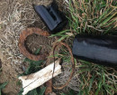
Deep Creek Inlet constitutes an archaeological site containing a number of archaeological and structural features. These features include a culvert, gate and wheel on a constructed platform, a low-timber edged platform of unknown purpose overlooking pondage within the main channel. Therefore, the Deep Creek Inlet site meets Threshold A (archaeology). Deep Creek Inlet has association with water supply processes in the Gunbower region and irrigation history in the region which is a key historic theme for the local area. As such, Deep Creek Inlet is significant at a local level. The Deep Creek Inlet site thus meets the Threshold B (place history).
Heritage Inventory Description
DEEP CREEK INLET - Heritage Inventory Description
Deep Creek Inlet at the eastern extent of Deep Creek Channel, contains a number of structural and archaeological features. On the western side of River Track, Deep Creek terminates in an area of pondage (which was dry at the time of field survey). A culvert under River Track is opened and closed with a gate operated by a wheel connected via a wooden platform at the high bank immediately west of River Track. Kaufman and Ballinger (2014) suggest that this was possibly constructed circa 1950, but considering the documented history of the site, the structure may be slightly older. The site exhibits a number of features. These features all appear to be associated with water regulation between Deep Creek and the Murray River. Noted features of this site include the following: • Wheel operated Gateway - The structure, constructed of timber, metal and brick appears quite robust. It is situated at the bottom of the Deep Creek channel cutting, immediately adjacent River Track. • Platform - Located in the channel depression overlooking the outflow for the wheel operated gateway, the purpose of this platform is unclear. Constructed of earth, with timber and brick edgings it measures approximately 6 m in length, 5 m in width and 0.6 m in height. • Outlet into channel- A concrete outlet within the Deep Creek Channel to the immediate east of River Track is located within the proposed construction footprint. The construction material for the pipe appears to be of a similar age to that below the wheel operated gateway and nearby concrete footing. • Concrete footing and pipes - A concrete footing, measuring 1.2 m x 1.2 m and sitting approximately 30 cm above the ground surface, and two large terracotta clay pipes, approximately 40 cm in diameter, were identified on the embankment adjacent the Murray River, immediately north of River Track. It is unclear what the original purpose of these features was. The footing is robust and may have been a base for machinery such as pumping equipment.
-
-
-
-
-
NORTH MELBOURNE POTTERYVictorian Heritage Inventory
-
STONY CREEK SLIPWAYVictorian Heritage Inventory
-
SEASONING WORKS SITE AND TERRACOTTA LUMBERWALLVictorian Heritage Inventory
-
-