Back to search results
ROBBIN'S HILL BATTERY
HUNTLY-FOSTERVILLE ROAD, FOSTERVILLE
ROBBIN'S HILL BATTERY
HUNTLY-FOSTERVILLE ROAD, FOSTERVILLE
All information on this page is maintained by Heritage Victoria.
Click below for their website and contact details.
Victorian Heritage Inventory
On this page:
Statement of Significance
What is significant?
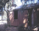
The site comprises the remains of a wooden stamp battery and presents a well-preserved example of a late 19th century wooden framed stamp battery. The site has the potential to contain archaeological deposits, features and artefacts associated with the use of the timber battery and archaeological deposits or artefacts prior mining occupation.
How is it significant?
The wooden stamp battery site is of local historical significance.
Why is it significant?
The wooden stamp battery site is of historical significance for its association with late 19th and early 20th century small scale gold mining in regional Victoria.
Gold mining in Fosterville can be characterised as a landscape of boom and bust. Many of the companies were small scale, made very little money, and the Fosterville area was colloquially referred to as the “Poor Man’s Goldfield” (Snoek 1988). Gold miners had to rely on the resources in their immediate vicinity, and the use of roughly hewn timber- irregularly hafted and bolted together, lends to this notion. The wooden stamp battery is representative of this adaptation to the landscape and the ingenuity and resourcefulness of the local gold miners. Insight into the miners’ lives and the operation of small scale gold mining in regional areas can be gained from this site.
Show more
Show less
-
-
-
-
NORTH MELBOURNE POTTERY
 Victorian Heritage Inventory
 -
STONY CREEK SLIPWAY
Victorian Heritage Inventory
-
SEASONING WORKS SITE AND TERRACOTTA LUMBERWALL
Victorian Heritage Inventory
-
-