Back to search results
DENICULL CREEK GOLD WORKINGS 2
DENNICULL CREEK ROAD CATHCART, ARARAT RURAL CITY
DENICULL CREEK GOLD WORKINGS 2
DENNICULL CREEK ROAD CATHCART, ARARAT RURAL CITY
All information on this page is maintained by Heritage Victoria.
Click below for their website and contact details.
Victorian Heritage Inventory
On this page:
Statement of Significance
What is significant?
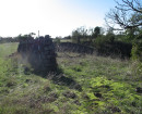
The subject site is associated with the gold-rush within the greater Ararat region and the development of the small town of Cathcart. The site was recorded as being/ worked by Chinese miners and therefore could provide insight into the cultural history of the region. While gold-digging in this area is not uncommon or rare, the subject site was surveyed in 1911 and there is evidence to suggest that various groups were digging at the site at the same time. In addition to Moderate that, the inclusion of the Mechanics Institute at the
site indicates that it may have been a community hub of sorts. As such, the site could provide insight into a community building in collaboration on the gold-fields. The subject site shows all the aspects of a classic alluvial gold mine, with hundreds of gold pits and potential shafts, drainage channel and spoil piles. Due to the intensity of the digging activities and lack of subsequent development, it does represent a fairly untouched and intact example of late 19th century gold mining.
site indicates that it may have been a community hub of sorts. As such, the site could provide insight into a community building in collaboration on the gold-fields. The subject site shows all the aspects of a classic alluvial gold mine, with hundreds of gold pits and potential shafts, drainage channel and spoil piles. Due to the intensity of the digging activities and lack of subsequent development, it does represent a fairly untouched and intact example of late 19th century gold mining.
How is it significant?
The subject site is associated with the gold-rush within the greater Ararat region and the development of the small town of Cathcart. The site was recorded as being/ worked by Chinese miners and therefore could provide insight into the cultural history of the region. While gold-digging in this area is not uncommon or rare, the subject site was surveyed in 1911 and there is evidence to suggest that various groups were digging at the site at the same time. In addition to Moderate that, the inclusion of the Mechanics Institute at the
site indicates that it may have been a community hub of sorts. As such, the site could provide insight into a community building in collaboration on the gold-fields. The subject site shows all the aspects of a classic alluvial gold mine, with hundreds of gold pits and potential shafts, drainage channel and spoil piles. Due to the intensity of the digging activities and lack of subsequent development, it does represent a fairly untouched and intact example of late 19th century gold mining.
site indicates that it may have been a community hub of sorts. As such, the site could provide insight into a community building in collaboration on the gold-fields. The subject site shows all the aspects of a classic alluvial gold mine, with hundreds of gold pits and potential shafts, drainage channel and spoil piles. Due to the intensity of the digging activities and lack of subsequent development, it does represent a fairly untouched and intact example of late 19th century gold mining.
Why is it significant?
The subject site is associated with the gold-rush within the greater Ararat region and the development of the small town of Cathcart. The site was recorded as being/ worked by Chinese miners and therefore could provide insight into the cultural history of the region. While gold-digging in this area is not uncommon or rare, the subject site was surveyed in 1911 and there is evidence to suggest that various groups were digging at the site at the same time. In addition to Moderate that, the inclusion of the Mechanics Institute at the
site indicates that it may have been a community hub of sorts. As such, the site could provide insight into a community building in collaboration on the gold-fields. The subject site shows all the aspects of a classic alluvial gold mine, with hundreds of gold pits and potential shafts, drainage channel and spoil piles. Due to the intensity of the digging activities and lack of subsequent development, it does represent a fairly untouched and intact example of late 19th century gold mining.
site indicates that it may have been a community hub of sorts. As such, the site could provide insight into a community building in collaboration on the gold-fields. The subject site shows all the aspects of a classic alluvial gold mine, with hundreds of gold pits and potential shafts, drainage channel and spoil piles. Due to the intensity of the digging activities and lack of subsequent development, it does represent a fairly untouched and intact example of late 19th century gold mining.
Show more
Show less
-
-
-
-
NORTH MELBOURNE POTTERY
 Victorian Heritage Inventory
 -
STONY CREEK SLIPWAY
Victorian Heritage Inventory
-
SEASONING WORKS SITE AND TERRACOTTA LUMBERWALL
Victorian Heritage Inventory
-
-