Costerfield Precinct
Donelly's Lane, Costerfield - Redcastle, Heathcote-Nagambie, Reservoir and North Costerfield Heathcote Roads, COSTERFIELD, GREATER BENDIGO CITY
![Greater Bendigo City](http://api.heritagecouncil.vic.gov.au/img/owner_icons/39.gif)
-
Add to tour
You must log in to do that.
-
Share
-
Shortlist place
You must log in to do that.
- Download report
![73478 Costerfield Town map 73478 Costerfield Town map](https://vhd.heritagecouncil.vic.gov.au/vhd-images/places/000/043/588.jpg)
![1133 Nagambie- Heathcote Road, Costerfield Precinct 1133 Nagambie- Heathcote Road, Costerfield Precinct](https://vhd.heritagecouncil.vic.gov.au/vhd-images/places/000/045/262.jpg)
Statement of Significance
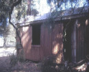
The Costerfield Gold and Antimony Mining Precinct consists of three sites including the Bombay Mine, Minerva Mine and Costerfield Main shaft. The precinct has a range of concrete, brick and timber foundations and mining earthworks that are remnants of ore extraction and processing operations from the 1890s to the 1940s. (Heritage Victoria H1298)
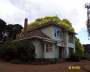
The township of Costerfield including the remaining mine buildings and other buildings included in the schedule below is significant.
How is it significant?The Costerfield Township Precinct is of local historic, aesthetic and social significance to the City of Greater Bendigo. The Costerfield Gold and Antimony Mining Precinct is of historical, archaeological and scientific importance to the State of Victoria.
Why is it significant?The Costerfield sites have a unique history among other Victorian gold mines. Although rich in gold, Costerfield ore became renowned for its antimony content. On three different occasions, 1861-83, 1905-22 and 1935-51 the complex ore was mined with great success. Costerfield was also historically important during the First World War when it was a major supplier of antimony to the British Government, the metal being vital for the manufacture of munitions. Criterion A
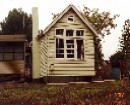
The remaining buildings in Costerfield demonstrate tangible evidence of a mining town that was active over a period of nearly ninety years. The buildings, although scattered throughout the precinct are of importance in providing a township setting to the mine and in understanding the relationship between the industry and those who worked there. The buildings provide evidence of the way of life of the township including social, religious and educational and recreational life as demonstrated by the church, school, hall, shop and former hotel, as well as a number of houses and cottages of different periods. Criterion C
Since 2006 Costerfield has again been the location of gold and antimony mining and although the present mining operations are conducted in a larger and more industrialised manner, Costerfield has significance for a new generation of people associated with the mining industry. Criterion G
-
-
Costerfield Precinct - Physical Description 1
The road layout of Costerfield is characteristic of towns that have developed without a formal survey. The allotments are irregular in shape and size, however east of the Costerfield Redcastle Road a survey of some allotments had been carried out by 1877. [1] The map also shows the extent of a mining lease over a large part of the town.
As Costerfield developed entirely as a result of mining operations the town has been through cycles of boom and bust. It previously had many more buildings than those that currently remain. Today Costerfield consists of a number of buildings scattered across a clearing surrounded largely by forest. The buildings include houses, a former hotel, school , shop and post office and the remnants of some mine buildings. Although relatively few in number, each of the buildings provide evidence of the town that once was more populated than today. The remaining buildings are not contiguous, located randomly and there are large parcels of land between them.
The shop and post office at 1133 Heathcote Nagambie Road is a picturesque group of timber buildings that form a key element to the township. The three main components of the building have frontages in three directions and the gable roofs are set perpendicular to each other. The central long gable is flanked by a small one room shop with verandah and chimney, and another another two room building with a very wide verandah. There is a small timber frieze across the front verandah and two brick chimneys.
The mining buildings and sites comprise extensive foundations and earthworks of the Bombay Mine, the Minerva Mine site with its corrugated iron battery shed and chimney stack, concrete foundations and other ruins associated with the Costerfield main shaft, and a reservoir. These sites are included on the Victorian Heritage Register.
The public hall at 1136 Heathcote Nagambie Road is on the site of land reserved for a Mechanics Institute. It is a timber framed building of five bays with gable roof. The cladding appears to be aluminium and the window frames have been replaced with aluminium. Original detail on the exterior is confined to the roof ventilators, barge boards and flagpole to the front gable end. There is a weatherboard outbuilding on the site.
The Costerfield State School at 8 Crossley Road comprises the classroom built in 1915 that once formed part of the 1875 school. The building has been altered, not only by the removal of the 1875 classroom, but also by the incorporation of additional windows and a verandah.
The former Costerfield Methodist Church is designed in the Primitive Gothic style and built in 1876. Elements of the style include the use of steeply gabled roof and pointed arch headed windows. The gable end is decorated with a small arched hood moulding above a rectangular the window.
3 Costerfield Redcastle Road is a timber framed gabled roof cottage with brick chimneys, straight profile verandah and a detached outbuilding, possibly a kitchen. A skillion addition connects the outbuilding. It is likely that this is the building that once served as a hotel. Another hotel was adjacent to the store at the other end of the town, but this has been demolished.
Aerial photos show Costerfield located in a clearing surrounded largely by State Forest, however the vegetation within the township is characterized by a mixture of native and exotic plantings. The exotics are mainly cypresses and pines. Trees are relatively sparse as the ground has been so disturbed by mining that there is little topsoil for them to establish. The extent of mining is also evident on an aerial of Costerfield.
[1] Plan of the Township of Costerfield, County of Dalhousie, survey by W. Robinson, 1877.
Costerfield Precinct - Integrity
Good
Costerfield Precinct - Historical Australian Themes
4 Transforming the land
4.5 Gold Mining
4.6 Exploiting other mineral, forest and water resources
Heritage Study and Grading
Greater Bendigo - Former Shires of McIvor and Strathfieldsaye Heritage Study
Author: Context P/L
Year: 2008
Grading: Local
-
-
-
-
-
COSTERFIELD GOLD AND ANTIMONY MINING PRECINCTVictorian Heritage Register H1298
-
OLD ALISON MINE SITEVictorian Heritage Inventory
-
NEW ALISON MINE SITEVictorian Heritage Inventory
-
-