Back to search results
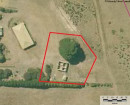
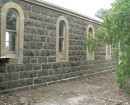
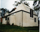
FORMER FAY'S HOTEL
WESTERN HIGHWAY BUANGOR, ARARAT RURAL CITY
FORMER FAY'S HOTEL
WESTERN HIGHWAY BUANGOR, ARARAT RURAL CITY
All information on this page is maintained by Heritage Victoria.
Click below for their website and contact details.
Victorian Heritage Inventory
On this page:
Statement of Significance
This record has minimal details. Please look to the right-hand-side bar for any further details about this record.
Show more
Show less
-
-
-
-
FORMER FAY'S HOTEL
 Victorian Heritage Inventory
 -
Eucalyptus camaldulensis
 National Trust
-
-