Coranderrk Aboriginal Station
19 Barak Lane Healesville, YARRA RANGES SHIRE
-
Add to tour
You must log in to do that.
-
Share
-
Shortlist place
You must log in to do that.
- Download report
Statement of Significance
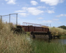
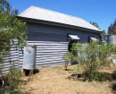
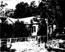
-
-
Coranderrk Aboriginal Station - Physical Description 1
There is a range of features relating to buildings and other places of activity located around the station property. The two-storey Superintendent's house (0027) (separately listed) is located approximately 400m along the entrance road to the station. It was constructed in 1883 of hand made bricks and has a small single-storey extension on its east wall, and a front verandah and entrance. Its dimensions are 13 metres north-south by 12.5 metres east-west (including verandah). There are a number of scarred trees around the station property. (Rhodes 1998: 46; Heritage Victoria)
A "kidney shaped" clay quarry pit and brick kiln (0024), is located approximately 100m north of the end of the entrance road. It is around 25 metres long, 12 metres wide and has a maximum depth of 2 metres. A number of possible or actual former building sites have been recorded around the station property (and have been given the following feature numbers; (0014), (0015), (0017), (0018), (0019), (0020), (0021), (0022), (0023), (0025), (0026), (0028), (0029)). Features (0021) and (0023) have surface artefact scatters associated with them. A single surface artefact scatter has also been identified on the property (0016). (Heritage Victoria; Rhodes 1998: 32)
Various historic trees, including a row of plane trees, an oak tree, various pine trees and the remains of an orchard, exist on the property. A guest house, three dams and some associated farm buildings are located on the property. (Rhodes 1998: 31)
For the purposes of conservation of its cultural significance, the extent of the Coranderrk Aboriginal Station includes the current property boundary, extending where necessary to include specific identified places of cultural significance: that is in the south the boundary is formed by Badger Creek along to the remains of the fruit orchard, then north-west to a point close to the cemetery, along Picaninny Lane to include the stockyard site and then following property boundaries meet with the entrance road to Coranderrk, and to southeast to meet Badgers Creek. (see plan)Coranderrk Aboriginal Station - Physical Conditions
Good
Heritage Study and Grading
Yarra Ranges - Shire of Yarra Ranges Heritage Study
Author: Context Pty Ltd
Year: 2000
Grading: State
-
-
-
-
-
HEALESVILLE RAILWAY STATION COMPLEXVictorian Heritage Register H1567
-
FORMER HEALESVILLE COURT HOUSEVictorian Heritage Register H1171
-
FORMER SHAMROCK HOTELVictorian Heritage Inventory
-
-