Back to search results
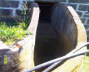
TAYLORS ROAD HOUSE AND CISTERN
875 TAYLORS ROAD DANDENONG SOUTH, GREATER DANDENONG CITY
TAYLORS ROAD HOUSE AND CISTERN
875 TAYLORS ROAD DANDENONG SOUTH, GREATER DANDENONG CITY
All information on this page is maintained by Heritage Victoria.
Click below for their website and contact details.
Victorian Heritage Inventory
On this page:
Statement of Significance
This record has minimal details. Please look to the right-hand-side bar for any further details about this record.
Show more
Show less
-
-
-
-
TAYLORS ROAD HOUSE AND CISTERN
 Victorian Heritage Inventory
 -
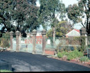
Noble Park Memorial Swimming Pool
 Vic. War Heritage Inventory
-
-