Back to search results
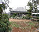
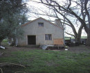
GHAZEEPORE ROAD RURAL STRUCTURE
290 GHAZEEPORE ROAD MOUNT DUNEED, GREATER GEELONG CITY
GHAZEEPORE ROAD RURAL STRUCTURE
290 GHAZEEPORE ROAD MOUNT DUNEED, GREATER GEELONG CITY
All information on this page is maintained by Heritage Victoria.
Click below for their website and contact details.
Victorian Heritage Inventory
On this page:
Statement of Significance
Site is of high archaeological significance for is scientific potential, aesthetic values & rarity. Med to high potential for archaeological subsurface deposits to be present.
Show more
Show less
-
-
-
-
-
GHAZEEPORE ROAD RURAL STRUCTURE
 Victorian Heritage Inventory
-
-