Ballarat East Civic Precinct

Statement of Significance
The Ballarat East Civic Precinct is historically significant at a LOCAL level (AHC criterion A and H).
9a) The place's importance in the course, or pattern, of Australia's natural or cultural history;
(a4) &(h1) Importance for association with events, developments, cultural phases and individuals which have had a significant role in the human occupation and evolution of the region.
The Precinct has historical importance for its association with the discovery of gold in the early 1850s and for its close relationship with the early development of Main Road, recognized as the commercial centre of the alluvial and deep lead mining area by 1853-1854. The profits generated from the sale of services and goods from the many commercial and retail ventures stretched along the length of Main Road from Bridge Street in the north through to Golden Point in the south were often reinvested among small co-operatives of miners. This helped to facilitate the commercial cooperation between miners and storekeepers that was so crucial while exploration of the Ballarat goldfields continued. It also created an integrated social and commercial system that helped to create the municipal framework of early East Ballarat.
The Precinct has historical importance for its association with the early development of East Ballarat as a municipality, with a separate political and social identity from West Ballarat. In spite of the many difficulties associated with its development on the main alluvial diggings site, in February 1857 sale of frontages (freehold land) in Main Road provided the basis for ratepayer to elect a local government and form the municipality of Ballarat East in 1857. Plans began shortly afterwards for a collection of civic and cultural buildings in Barkly Street off Main Road including a Town Hall, Police Court, Mechanics Institute, Museum and Public Library.
The Precinct has historical importance for its substantially intact physical evidence, scarce examples of the now defunct transient mining development along Main Road which because of its flood prone, low lying ground made it a most unsuitable site for a permanent commercial centre. The priority given to alluvial and deep lead mining interests in this area helps to explain the distinctive street pattern through the Ballarat East Civic precinct. Streets and lanes developed organically from the main arteries and the urban pattern is in stark contrast to the formal surveyed grid layout of Ballarat West.
The Ballarat East Civic Precinct is socially significant at a LOCAL level (AHC criterion G.1).
(g) the place's strong or special association with a particular community or cultural group for social, cultural or spiritual reasons;
The Precinct is recognised and highly valued by the local community for civic, religious and educational reasons. Collectively, the civic buildings surviving in East Ballarat are symbols of the way in which the residents of East Ballarat developed and indeed, cultivated a separate municipal, political and social identity from the township above on the plateau.
The Ballarat East Civic Precinct is architecturally significant at a LOCAL level (AHC criteria D.2, E.1).
(d) the place's importance in demonstrating the principal characteristics of: (i) a class of Australia's natural or cultural places; or (ii) a class of Australia's natural or cultural environments; (e) the place's importance in exhibiting particular aesthetic characteristics valued by a community or cultural group;
The Precinct is architecturally important for its association with the location of the new civic centre and municipality of East Ballarat, which was built on one of the highest points in the area with commanding views over much of mining activity in Yarrowee creek below. The new town hall (1861demolished 1949) with its later formal botanic garden glasshouse and fernery was a symbol of order and civilization in contrast with the ad hoc transient nature of life on the diggings. The associated civic buildings incorporated the full range of facilities symbolic of cultivated European society in the nineteenth century inclusive of a museum and library for education and self-improvement and a police court as an instrument of law and order. Contemporary maps show that the site was one of few locations left relatively untouched by direct mining works such as the nearby shafts of the Britannia United Shaft, Eastern Star Extension and Sulieman Pasha No. 2 mining sites. Although the Town Hall was demolished in 1949, other buildings in the civic precinct remain. These include 1867 the Ballarat East Free Library (1867) and the Ballarat Fire Station and brick tower (1864-67) which has historical significance as one of the few remaining examples of nineteenth century fire stations. Other buildings include the Wesleyan Methodist Church and the Jewish Synagogue, hall and Rabbi's residences which are among the oldest buildings in the Precinct, constructed in 1860 and 1861 respectively.
The Precinct is architecturally important for it demonstrates many original and intact architectural design qualities associated with the residential, civic, and cultural/community development of the area between the 1850s and the late 1930s.
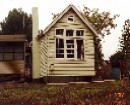
While civic and cultural life was the primary function of buildings within this precinct, scattered pockets of residential buildings developed from the late 1850s onwards. The eastern end of Barkly Street was constructed within the vicinity of the Gravel Pits Lead and the Fire Brigade Reef while there was also shallow alluvial mining activity in the surrounding area. The cottages provided accommodation for miners. The precinct still contains scattered examples of very early cottages, possibly built under the provisions of the Miner's Right. By 1866, Crown sales of small residential allotments with frontages of between 26 feet and approximately 75 feet had taken place along East and Barkly Streets. The Precinct also contains examples of later Victorian style housing constructed towards the latter part of the nineteenth century when mining was becoming a less dominant force within East Ballarat. Similarly, there are a number of examples of buildings erected from the turn of the century to the end of the inter-war period, as the area developed more structured residential pockets alongside the early civic and cultural buildings
The Ballarat East Civic Precinct is aesthetically significant at a LOCAL level (AHC criteria D.2, E.1).
(d) the place's importance in demonstrating the principal characteristics of: (i) a class of Australia's natural or cultural places; or (ii) a class of Australia's natural or cultural environments; (e) the place's importance in exhibiting particular aesthetic characteristics valued by a community or cultural group;
The Precinct has aesthetic significance as a 19th century gold mining townscape which demonstrates important visual qualities that reflect the historical, cultural and architectural development of the Precinct, and contribute to the setting of Ballarat. These qualities are substantially demonstrated by the significant urban foci, notably the Synagogue and associated Canary Island Pine, which form an important focus to arrival at the eastern edge of the Precinct; the Ballarat Fire station, which due to its position on high ground at the divergence of two streets and its imposing tower, forms a dramatic landmark on the skyline and can be seen from many vantage points both within and outside of the precinct; the strong streetscape elements of the former Wesleyan Methodist complex of buildings, which includes the Church, the hall, and the former parsonage; the strong streetscape element of the former East Ballarat Free Library with its associated original fence; the original fencing, entrance gates and the mature exotic trees to the former Ballarat East Town Hall Gardens, which provide a scenic garden focus along Barkly Street at the western edge of the Precinct; the original large cast-iron gas lamp in the centre of the Barkly Street and East Street South intersection; and the significant visual connections between all of the above-mentioned buildings and significant streetscape elements, and their juxtaposition with the pockets of intact and generally well-maintained residential buildings
The Ballarat East Civic Precinct is scientifically significant at a LOCAL level (AHC criterion C.2).
(c) the place's potential to yield information that will contribute to an understanding of Australia's natural or cultural history.
The Precinct is of importance for contributing to a history of the infrastructure development of Ballarat East, as identified by the significantly intact bluestone channels, gutters and kerbs, and the asphalt footpaths.
-
-
-
-
-
MITRE TAVERN
 Victorian Heritage Register H0464
 -
MELBOURNE SAVAGE CLUB
Victorian Heritage Register H0025
-
FORMER LONDON CHARTERED BANK
Victorian Heritage Register H0022
-
-