Soldiers Hill Precinct

Statement of Significance
The Soldiers Hill Precinct is historically significant at a LOCAL level (AHC criteria A.4 and H.1).
(a) the place's importance in the course, or pattern, of Australia's natural or cultural history;
(a.4) importance for association with events, developments or cultural phases which have had a significant role in the human occupation and evolution of the nation, State, region or community;
(h) the place's special association with the life or works of a person, or group of persons, of importance in Australia's natural or cultural history.
The Precinct is a broad historical townscape founded in 1850s, associated with the expansion of military presence on the Ballarat gold fields following the Eureka uprising in 1854, when the original Police Camp, located in Lydiard Street, was reinforced by the establishment of a large military and police encampment nearby, on Soldiers Hill.
The Soldiers Hill Precinct was laid out under neoclassical auspices of hierarchy and axial ordering. It was surveyed by the colonial Government Surveyor W.S.Urquhart in late 1851, and the first lands sales took place in 1859 to the late 1860s. The area is historically important as it is an early example of a highly desirable mid 19th century goldfields residential area. Its popularity was due to its elevated position away from nearby gold mining activities and noxious industries. The early phase of development with its rectilinear street layout pattern reflects typical 19th century geometric neoclassical planning style based on public order with scattered clusters of commercial activities sited on major road intersections, interspersed with a range of denominational landmark ecclesiastical buildings and schools and uniform residential allotments. There was a significant phase of re-building and architectural consolidation during the late 19th century together with urban beautification schemes associated with major avenue re-planting of gums and pines with elms and plane trees, and infrastructure development identified by the extensive network of significantly intact bluestone channel drains, gutters and kerbs. The area remains predominately residential although later architectural development and infill became more eclectic in style. Through this process of consolidation and infill over the past 120 years, the urban fabric has been extended on the same pattern as the first mid 19th century layout and the harmony of the overall townscape has been retained.
The Soldiers Hill Precinct is architecturally significant at a LOCAL level (AHC criteria D.2, E.1).
(d) the place's importance in demonstrating the principal characteristics of: (i) a class of Australia's natural or cultural places; or (ii) a class of Australia's natural or cultural environments; (e) the place's importance in exhibiting particular aesthetic characteristics valued by a community or cultural group;
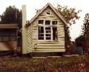
The Precinct is a significant 19th and early 20th century example of residential area representing the development of modern urbanism, initiated by the 1850s gold rush in rural Victoria. The economic success of the town due to gold mining allowed for the development of a city that responded to the needs of a rising middle class. The new ideas that underpinned the urban plan of Soldiers Hill Precinct, resulting from concern of the civic role of public spaces and the need for natural light and ventilation to foster public hygiene, is also reflected by its collection of architectural buildings. The buildings demonstrates many original and intact design qualities associated with a diverse range of small scale predominately single-storey residential Victorian, Federation, and later Inter-War and early Post-War era buildings as well as a notable ensemble of commercial, cultural/community and educational development constructed between the 1860s and 1940s, and into the early 1950s. Many of the churches were designed by leading Victorian architects such as those designed by architects, J. A Doane (Weslyan Church), Leonard Terry (St. John's Anglican Church) and Figgis & Molloy (Scots Church). In contrast to the dominant elements of the churches other landmark structures in the precinct include examples of former industrial buildings such as the galvanised corrugated iron walling of the former Chaff Mill. Of particular significance in the hierarchical ordering of space and elements in the precinct is the adaptation of the urban plan to the introduction of the motor vehicle in the early 20th century and resulting design response to private garages which are sited at the rear of dwellings. The success of a unifying aesthetic ideal derived from overseas 19th century and early 20th century architectural and planning ideas adapted to a provincial Australian model is evidenced by the diverse array of often eclectic building styles in the precinct which collectively contribute to a visually unified townscape of beauty.
The Soldiers Hill Precinct is aesthetically significant at a LOCAL level (AHC criteria D.2, E.1).
(d) the place's importance in demonstrating the principal characteristics of: (i) a class of Australia's natural or cultural places; or (ii) a class of Australia's natural or cultural environments; (e) the place's importance in exhibiting particular aesthetic characteristics valued by a community or cultural group;
The Precinct demonstrates important visual qualities that reflect the historical, cultural and architectural development of the precinct, and contribute to its 19th century urban plan and townscape setting. The 19th century neo-classical town planning concepts based on a regular grid with wide streets and absolute regularity of its grid gives way in the west and south to a number of crescents in response to abrupt changes in topography and introduction of the railway reserve. These features provide its special visual qualities, including complex views across and through the Precinct to other parts of Ballarat as well as east to Black Hill and further south-east to Mount Warrenheip. Despite a considerably variation in allotment sizes and topography, important internal urban and architectural views are created by the harmonious collection of a diverse range of residential architectural styles of similar scale, setback, orientation and construction material set within in a rigid geometric layout of tree lined avenues. Also of importance are the views of highly significant 19th century engineering infrastructure, including the Gnarr Creek Channel, which transects the residential area in the west part of the Precinct.
Further important aesthetic qualities of the Precinct include the variety of significant urban landmarks, a number of which can be seen from outside of the Precinct. These comprise each of the churches and their associated buildings, but particularly the Scots Presbyterian Church in Lydiard Street North with its dominant spire, and the St. Columba's Catholic Church with its notable campanile-like tower; each of the schools and their associated buildings, but particularly the dominant two-storey Macarthur Street
State School No.2022; the numerous corner shops and hotels (both present and former), as well as the small shops visible along various residential streetscapes, which provide focal points of interest to the long streets and particularly help to define many of the street intersections to the extent that many have become local landmarks; and the open landscape of the Walter Jones Reserve and the associated stand of mature cypress trees, which provide a scenic garden focus within the dominant residential area of this part of the Precinct. The important visual qualities of the Precinct are also enhanced by the mature and juvenile street tree plantings that are a significant component of many of the streetscapes; by the gravel/grass road shoulders and turf nature strips or footpaths; by areas of grassed and variously landscaped public and private open spaces such as the Walter Jones Reserve, school grounds, and the many private gardens with their mature canopy trees. These landscaped and treed areas provide the Precinct with a garden setting of considerable variety. Furthermore, the visual qualities of the Precinct are specially enhanced by the substantial integrity of the original engineering infrastructure, particularly as identified by the extensive network of bluestone spoon or channel drains, and bluestone inverted channel gutters with bluestone pitcher kerbs, and by the wrought iron drain guards.
The Soldiers Hill Precinct is scientifically significant at a LOCAL level (AHC criteria C.2 and F1).
(c) the place's potential to yield information that will contribute to an understanding of Australia's natural or cultural history.
(f) the place's importance in demonstrating a high degree of creative or technical achievement at a particular period.
The substantial integrity of the original engineering infrastructure, particularly as identified by the extensive network of bluestone drains is of importance for demonstrating the modern concepts of urban planning based on new order, hygiene and services. The use of bluestone pitchers as the principal material to form this type of engineering infrastructure also demonstrates an early, and now rarely used construction technology and the excellence of traditional craftsmanship.
The Soldiers Hill Precinct is socially significant at a LOCAL level (AHC criterion G.1).
(g) the place's strong or special association with a particular community or cultural group for social, cultural or spiritual reasons;
The Precinct is recognized and highly valued by the local community for its early and ongoing residential, commercial, social, educational, and recreational associations. It is furthermore recognized and highly valued by the local community for its past industrial associations.
-
-
-
-
-
MITRE TAVERN
 Victorian Heritage Register H0464
 -
MELBOURNE SAVAGE CLUB
Victorian Heritage Register H0025
-
FORMER LONDON CHARTERED BANK
Victorian Heritage Register H0022
-
-