Back to search results
BRICK RUIN
off Coleraine-Nareen Road NAREEN, Southern Grampians Shire
BRICK RUIN
off Coleraine-Nareen Road NAREEN, Southern Grampians Shire
All information on this page is maintained by Southern Grampians Shire.
Click below for their website and contact details.
Southern Grampians Shire
On this page:
Statement of Significance
What is significant?
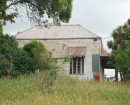
Sunnyside is located about 500m off the Coleraine-Nareen Road on the eastern side and about 750m north of the intersection with McDougall's Lane. The complex consists of the ruins of a substantial brick house and timber woolshed, set in the remains of a large garden, with several surviving mature trees and an orchard. Sunnyside was developed by the Neeson family, who purchased the land as selectors in 1865, building the house when they settled on the land after 1867. The land has been retained in the Neeson family for over 130 years. There has been no architect or builder associated with the design of the house or woolshed.
How is it significant?
Sunnyside is of historical and archaeological significance to the community of Nareen and the Southern Grampians Shire.
Why is it significant?
Sunnyside is historically significant as a representative example of a successful selectors homestead dating from the late 1860s. The close proximity of house, orchard and woolshed demonstrates the self sufficiency of those who came looking for land in the 1860s and 1870s after the Land Selection Acts. Sunnyside has further historical significance for its long history of ownership by an important local family, the Neesons, who have been in continuous ownership of this property since 1865. Sunnyside has archaeological significance for its potential to yield further artifacts and information which will provide us with a better understanding of our past and the way we once lived.
Show more
Show less
-
-
-
-
CUYUAC HOMESTEAD COMPLEX
 Southern Grampians Shire
 -
WAR MEMORIAL
Southern Grampians Shire
-
NAREEN HALL COMPLEX
Southern Grampians Shire
-
'The Pines' Scout Camp
 Hobsons Bay City
 -
106 Nicholson Street
 Yarra City
 -
12 Gore Street
Yarra City
-
-