HO109 - Old Rockbank Middle Road (Cobblestone Road)
In Reserve, The Bridges CAROLINE SPRINGS, MELTON SHIRE
-
Add to tour
You must log in to do that.
-
Share
-
Shortlist place
You must log in to do that.
- Download report
Statement of Significance
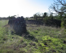
The Old Rockbank Middle Road (Cobblestone Road) cobblestone paving is significant as a scarce surviving remnant of early composite Telford and Macadam style stone road construction techniques, in use until the early decades of the twentieth century, after which developments they were superseded by asphalt and the advent of motorised traffic. Probably built in the early years of the twentieth century, the road is of a style that appears to have been particularly associated with the western and northern volcanic outskirts of Melbourne; the dozen or so remnants of such paving in Melton Shire would appear to be one of the larger collections of such roads. Unlike most of these roads, Old Rockbank Middle Road (Cobblestone Road) is not subject to threat from future roadworks.
The Old Rockbank Middle Road (Cobblestone Road) road paving is historically significant at a LOCAL level (AHC A.4, B2, D2). The route itself was likely part of an early alternative route used by squatters situated on the Kororoit Creek to the lower crossings of the Maribyrnong River. It was formally proclaimed in the Parish of Derrimut survey c.1852. In the late nineteenth century all the land along the road was route acquired as part of the massive Clarke Rockbank pastoral estate, and it is unlikely that there would have been any need for a paved road until the break-up and sale of the estate for farming allotments in the first decade of the twentieth century. The making of 'knapped' roads (as they were known) was common practice in the Shire around this time.
The Old Rockbank Middle Road (Cobblestone Road) road paving is scientifically significant at a LOCAL level (AHC C2). It is one of a small group of early knapped or cobbled basalt roads that survive in the Shire of Melton. These roads have the potential to be a significant repository of knowledge regarding early road construction, not only in the locality, but in Victoria. Old Rockbank Middle Road (Cobblestone Road) was identified as being of potentially high scientific and historical significance in an early study, and has since been subject to more detailed archaeological studies and conservation. It demonstrates a construction technique that is today both rare and, despite its relatively recent date, primitive in style. The volcanic areas to the west and north of Melbourne appear to have had a particular prominence in variations of this Telford style of construction, in which basalt was hand-hewn into rectangular shapes that were then wedged into a prepared earth foundation, with larger basalt blocks as edges, the whole being covered with crushed rock or 'metal'. While over a dozen of these roads were identified in this study, Old Rockbank Middle Road (Cobblestone Road) is one of only two that would appear not to be under threat of destruction by future road works. It is also the only one which has been subject to archaeological investigation, and has the potential to provide comparison with other stone based roads that may be subject to similar investigation in the future.
-
-
HO109 - Old Rockbank Middle Road (Cobblestone Road) - Physical Description 1
Physical Description -
Old Rockbank Middle Road (Cobblestone Road) comprises a remnant of early road construction, known in the local area (at least) as 'knapping'. Knapping was the process of breaking stones into irregular but generally uniform roughly rectangular spalls with a knapping hammer, and then hammered vertically into a prepared earthen surface. Some roads appear to have been slightly convex. Some, including Rockbank Middle Road, had drainage by way of earthen ditches (usually shallow) on either side. The edges of the bluestone paving were usually uniformly constructed of much larger basalt blocks. Smaller crushed rock aggregate ('metal') appears to have been added, and then gravel. The bluestone paving generally appears to have been c.3.2 - 5.4 metres wide in the Shire of Melton. Presently a bypassed portion of Rockbank Middle Road, it is now situated within a public open space west of Caroline Springs Boulevard. A 1990 archaeological report by Vines described Old Rockbank Middle Road (Cobblestone Road) as retaining:
'. its bluestone cobbled base and dry stone walls on either side. It is a well preserved example of a mid to late 19th century country road. The cobble stone construction used large stones along the edges . to provide a stable foundation. These were covered with smaller stones with extra attention given to providing two smooth tracks where the wagon wheels rain, the centre being more rough. The road would originally have been finished with a smooth wearing surface of sand or gravel.'[1]
The next archaeological report of the area in 1995 by du Cros and Murphy noted that the road constituted 'bluestone cobbling and deep ditches occur along most of the road'. This paving apparently survives underneath the section now visible. The report concluded that this site was 'Probably the best of its kind in the state'. However this statement does not appear to have been supported by comparative analysis, and the report also recommends that 'further research into the occurrence of roads of this kind around the state needs to be done before declaring it of state significance'. It concluded that the road was likely to be of 'high' scientific and historical significance.[2]
In 1998 du Cross and Peters conducted a more detailed historical and archaeological assessment of the road. They found that sections were largely intact, while other sections had deteriorated markedly. 'The intact sections and associated dry stone walls nevertheless formed a unique part of the historical landscape.' The site was assessed as being of very high scientific significance and regional historical significance, and place on the Victorian Heritage Inventory (H7822/188). It was noted that remains of a similar roads existed on Clarkes Road to the east, but that 'little is known of their methods of construction.' Similar remnant construction at Taylors and Gourley Roads to the north were also noted, and it was surmised that these northern roads, with hard edges and an almost 'flagged' surface, with wheel ruts (Taylors Road), may have been constructed in a different, earlier, technique. (It recommended that the Shire of Melton liaise with Heritage Victoria regarding the future of these other sites.) [3]
The report recommended that a portion of the road and associated dry stone walls be retained and interpreted as an historical landscape, and that removed road and walls be recorded in some detail.
In 1999 a cross section of the road was subject to archaeological excavation in order to help determine its method of construction. It found that the bluestone road to be 3.5 metres wide, within a 20 metre road reservation. The basalt was found to have been broken, but remnant rounded natural surfaces suggested the use of stone collected from around the surrounding volcanic plains rather than a quarry. (The location of the remnant roads found in this Heritage Study, in areas of volcanic fieldstone, also supports this conjecture.) The stones were mostly tightly wedged together, apparently deliberately hand-keyed with 'considerable skill', and then 'fixed in place by a mixture of basalt rubble and clay'. The road had a hard edge.[4]
The authors considered that the form of construction was a technique known to have been popular in the early twentieth century, and sometimes called the 'rock bottom road'. It combined the Telford had packed spalls (as evident in many roads around Melton Shire), over which coarse metal was spread and then topped with smaller metal and bound and rolled (akin to the Macadam method).[5]
In 1999 Biosis Research Pty Ltd and owner Delfin Property Group Pty Ltd selected a section of the roadway for conservation; the sections east and west were destroyed.[6]
To the east of the site is the Neales Road ford (Heritage Study Place No.422; Victorian Heritage Inventory H7922/161), which was the continuation of Old Rockbank Middle Road over the Kororoit Creek. It comprises large flat stones placed randomly across shallow part of ford, to which some concrete has been added. It apparently remains in use, with gravel track on both sides, and parkland on east side, coinciding with former Water Reserve (outside study area). This is not regarded as part Place No.341 in this heritage study.
[1] G Vines / Melbourne's Living Museum of the West, 'Report on the Historical and Archaeological Survey for the Melton East Structure Plan Survey Area' (September 1990), p.16. (It is probably more likely that the carts created their own smooth surface through wear.)
[2] H du Cros, A Murphy, 'An Archaeological Survey of the Proposed Caroline Springs Housing Development Area, East Melton, Victoria' (June 1995), p.31
[3] H du Cros, SJ Peters, 'Rockbank Middle Road Historical and Archaeological Assessment: Final Report' (April 1998), passim.
[4] S Lane, D Rhodes, 'The Art of Road Construction: Evaluation of Rockbank Middle Road Caroline Springs Middle Neighbourhood' (November 1999), passim.
[5] Lane, Rhodes, op cit, p.9.
[6] Lane, Rhodes, op cit, Section 2.
HO109 - Old Rockbank Middle Road (Cobblestone Road) - Historical Australian Themes
Melton Historical Themes: 'Transport'
HO109 - Old Rockbank Middle Road (Cobblestone Road) - Integrity
Integrity - Substantially Intact
HO109 - Old Rockbank Middle Road (Cobblestone Road) - Physical Conditions
Physical Condition - Fair
Heritage Study and Grading
Melton - Shire of Melton Heritage Study phase 2
Author: David Maloney, David Rowe, Pamela Jellie, Sera Jane Peters
Year: 2007
Grading:
-
-
-
-
-
'Mororo' 13 Oxford Street, MalvernStonnington City
-
1 Arnold StreetYarra City
-
1 Austin StreetYarra City
-
-